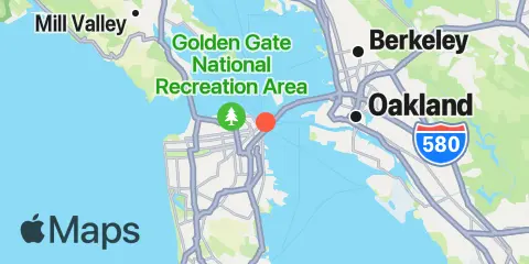
Rincon Point Tides & Fishing Times
Tides
About this chart
 High fish activity
 Very high fish activity
Rincon Point tide chart key:
The tide chart above shows the times and heights of high tide and low tide for Rincon Point, as well as solunar period times (represented by fish icons). The red line highlights the current time and estimated height.Two fish mark minor solunar periods (high fish activity); four fish mark major solunar periods (very high fish activity).
| Day | Time | Tide | Height | |
|---|---|---|---|---|
| ▼ Low | -0.46′ | |||
| ▲ High | 5.22′ | |||
| ▼ Low | 3.16′ | |||
| ▲ High | 5.76′ | |||
| ▼ Low | -0.17′ | |||
| ▲ High | 5.52′ |
: The tide at Rincon Point, Pier 22½, San Francisco Bay is falling, with an estimated height of 5.23 ft. The next low tide is -0.17 ft at . Current forecast: Clear; W winds at 11 mph, gusting to 20 mph; open-water waves around 2.2 ft. Today’s tidal range is approximately 6.05 ft.
Tidal range for : 6.05 ft (minimum -0.29 ft, maximum 5.76 ft).
Local times Heights in ft relative to MLLW
Weather & Marine Forecast
Sunday, November 1, 2026: Conditions: Clear; air temperatures of 52–58°F through tonight; winds at 3–11 mph, gusting to 20 mph; open-water waves around 2.2 ft–2.3 ft. Estimated water temperature is 63°F as of 5:00 PM.
| Date | Sun, Nov 1 | Mon, Nov 2 | Tue, Nov 3 | Wed, Nov 4 | Thu, Nov 5 | Fri, Nov 6 | Sat, Nov 7 | ||||||||||||||||||||||||||||||||||||||||||||||||||||||||||||||||||||||||||||||||||||||||||||||||||||||||||||||||||||||||||||||||||||||||
|---|---|---|---|---|---|---|---|---|---|---|---|---|---|---|---|---|---|---|---|---|---|---|---|---|---|---|---|---|---|---|---|---|---|---|---|---|---|---|---|---|---|---|---|---|---|---|---|---|---|---|---|---|---|---|---|---|---|---|---|---|---|---|---|---|---|---|---|---|---|---|---|---|---|---|---|---|---|---|---|---|---|---|---|---|---|---|---|---|---|---|---|---|---|---|---|---|---|---|---|---|---|---|---|---|---|---|---|---|---|---|---|---|---|---|---|---|---|---|---|---|---|---|---|---|---|---|---|---|---|---|---|---|---|---|---|---|---|---|---|---|---|---|---|
| Forecast | |||||||||||||||||||||||||||||||||||||||||||||||||||||||||||||||||||||||||||||||||||||||||||||||||||||||||||||||||||||||||||||||||||||||||||||||
| Weather °F Precip |
58°
|
56°
|
55°
|
54°
|
54°
|
53°
|
52°
|
51°
|
51°
|
51°
|
51°
|
51°
|
51°
|
51°
|
51°
|
54°
|
58°
|
59°
|
62°
|
64°
|
64°
|
64°
|
63°
|
62°
|
60°
|
58°
|
57°
|
57°
|
57°
|
58°
|
59°
2%
|
58°
2%
|
58°
2%
|
58°
2%
|
58°
2%
|
57°
2%
|
56°
33%
|
55°
33%
|
57°
33%
|
58°
33%
|
58°
33%
|
58°
33%
|
59°
64%
|
60°
64%
|
60°
64%
|
62°
64%
|
62°
64%
|
62°
64%
|
61°
40%
|
60°
40%
|
59°
40%
|
59°
40%
|
58°
40%
|
58°
40%
|
58°
11%
|
57°
11%
|
57°
11%
|
56°
11%
|
56°
11%
|
55°
11%
|
55°
5%
|
55°
5%
|
54°
5%
|
56°
5%
|
58°
5%
|
59°
5%
|
61°
3%
|
62°
3%
|
63°
3%
|
64°
3%
|
64°
3%
|
64°
3%
|
62°
|
61°
|
60°
|
60°
|
60°
|
59°
|
59°
1%
|
59°
1%
|
59°
1%
|
58°
1%
|
58°
1%
|
58°
1%
|
58°
1%
|
58°
1%
|
58°
1%
|
59°
1%
|
61°
1%
|
64°
1%
|
66°
1%
|
68°
1%
|
69°
1%
|
68°
1%
|
69°
1%
|
66°
1%
|
64°
|
62°
|
60°
|
60°
|
60°
|
60°
|
59°
1%
|
59°
1%
|
58°
1%
|
58°
1%
|
58°
1%
|
58°
1%
|
58°
2%
|
57°
2%
|
58°
2%
|
60°
2%
|
62°
2%
|
65°
2%
|
67°
1%
|
69°
1%
|
70°
1%
|
69°
1%
|
67°
1%
|
66°
1%
|
65°
|
63°
|
62°
|
62°
|
62°
|
62°
|
62°
|
62°
|
62°
|
62°
|
61°
|
61°
|
60°
|
60°
|
61°
|
63°
|
65°
|
68°
|
71°
|
73°
|
75°
|
75°
|
73°
|
| Wind mph | 11 Gust 20 | 9 Gust 19 | 9 Gust 18 | 7 Gust 15 | 6 Gust 11 | 6 Gust 8 | 3 Gust 8 | 3 Gust 9 | 2 Gust 9 | 3 Gust 9 | 3 Gust 8 | 2 Gust 7 | 2 Gust 4 | 2 Gust 3 | 5 Gust 6 | 4 Gust 8 | 5 Gust 6 | 4 Gust 5 | 3 Gust 5 | 1 Gust 4 | 3 Gust 6 | 6 Gust 9 | 7 Gust 9 | 6 Gust 9 | 4 Gust 9 | 5 Gust 10 | 5 Gust 11 | 5 Gust 9 | 4 Gust 5 | 3 Gust 5 | 5 Gust 7 | 4 Gust 7 | 5 Gust 4 | 7 Gust 6 | 9 Gust 6 | 6 Gust 7 | 6 Gust 9 | 6 Gust 11 | 6 Gust 11 | 7 Gust 13 | 8 Gust 14 | 4 Gust 4 | 7 Gust 11 | 8 Gust 7 | 8 Gust 9 | 6 Gust 7 | 6 Gust 6 | 5 Gust 4 | 3 Gust 1 | 2 Gust 3 | 3 Gust 3 | 2 Gust 4 | 1 Gust 4 | 2 Gust 3 | 2 Gust 4 | 2 Gust 3 | 3 Gust 3 | 3 Gust 3 | 3 Gust 4 | 4 Gust 3 | 4 Gust 4 | 4 Gust 4 | 3 Gust 3 | 3 Gust 3 | 3 Gust 3 | 4 Gust 6 | 5 Gust 7 | 5 Gust 8 | 5 Gust 8 | 3 Gust 6 | 4 Gust 6 | 7 Gust 6 | 9 Gust 7 | 8 Gust 7 | 6 Gust 4 | 3 Gust 2 | 2 Gust 2 | 1 Gust 3 | 1 Gust 3 | 3 Gust 4 | 3 Gust 4 | 2 Gust 3 | 0 Gust 1 | 2 Gust 2 | 2 Gust 1 | 2 Gust 2 | 2 Gust 2 | 2 Gust 2 | 3 Gust 3 | 4 Gust 5 | 4 Gust 5 | 5 Gust 6 | 7 Gust 8 | 7 Gust 9 | 5 Gust 7 | 7 Gust 6 | 7 Gust 6 | 7 Gust 6 | 7 Gust 5 | 6 Gust 5 | 4 Gust 4 | 4 Gust 4 | 3 Gust 4 | 3 Gust 4 | 2 Gust 3 | 1 Gust 3 | 1 Gust 2 | 2 Gust 2 | 2 Gust 2 | 3 Gust 2 | 3 Gust 2 | 3 Gust 2 | 3 Gust 2 | 3 Gust 2 | 4 Gust 3 | 5 Gust 4 | 6 Gust 6 | 6 Gust 7 | 7 Gust 8 | 6 Gust 9 | 6 Gust 7 | 4 Gust 4 | 3 Gust 2 | 3 Gust 2 | 2 Gust 2 | 1 Gust 3 | 1 Gust 3 | 2 Gust 2 | 3 Gust 2 | 3 Gust 2 | 4 Gust 2 | 4 Gust 2 | 4 Gust 3 | 4 Gust 3 | 4 Gust 3 | 4 Gust 3 | 4 Gust 2 | 3 Gust 2 | 3 Gust 2 | 3 Gust 3 | 2 Gust 4 | 2 Gust 6 | 6 Gust 8 |
| Waves | 2.2′ 10 sec | 2.2′ 9.9 sec | 2.3′ 9.9 sec | 2.3′ 10.1 sec | 2.3′ 10.3 sec | 2.3′ 10.6 sec | 2.2′ 11 sec | 2.2′ 11.6 sec | 2.2′ 12.1 sec | 2.2′ 12.6 sec | 2.2′ 13.1 sec | 2.2′ 13.6 sec | 2.2′ 14 sec | 2.3′ 14.3 sec | 2.3′ 14.6 sec | 2.3′ 14.9 sec | 2.4′ 15.1 sec | 2.4′ 15.2 sec | 2.4′ 15.3 sec | 2.4′ 15.4 sec | 2.5′ 15.5 sec | 2.5′ 15.5 sec | 2.5′ 15.5 sec | 2.5′ 15.5 sec | 2.5′ 15.5 sec | 2.6′ 15.5 sec | 2.6′ 15.5 sec | 2.6′ 15.3 sec | 2.6′ 15.2 sec | 2.6′ 15 sec | 2.6′ 15 sec | 2.6′ 15 sec | 2.6′ 14.9 sec | 2.6′ 14.9 sec | 2.6′ 14.8 sec | 2.6′ 14.7 sec | 2.6′ 14.5 sec | 2.5′ 14.3 sec | 2.5′ 14.1 sec | 2.5′ 13.9 sec | 2.6′ 13.7 sec | 2.6′ 13.2 sec | 2.8′ 12.4 sec | 2.9′ 11.4 sec | 3.1′ 10.6 sec | 3.1′ 10.2 sec | 3.3′ 10.2 sec | 3.3′ 10.1 sec | 3.3′ 10.1 sec | 3.4′ 10.2 sec | 3.4′ 10.2 sec | 3.4′ 10.2 sec | 3.5′ 10.1 sec | 3.5′ 10.1 sec | 3.5′ 10 sec | 3.5′ 10 sec | 3.6′ 9.9 sec | 3.6′ 9.9 sec | 3.7′ 9.9 sec | 3.7′ 10 sec | 3.7′ 10 sec | 3.7′ 10.1 sec | 3.7′ 10.2 sec | 3.6′ 10.2 sec | 3.5′ 10.2 sec | 3.5′ 10.2 sec | 3.4′ 10.2 sec | 3.4′ 10.2 sec | 3.3′ 10.2 sec | 3.3′ 10.1 sec | 3.3′ 10 sec | 3.2′ 9.9 sec | 3.2′ 9.5 sec | 3.2′ 9.1 sec | 3.2′ 8.8 sec | 3.2′ 8.5 sec | 3.3′ 8.4 sec | 3.3′ 8.2 sec | 3.2′ 8.2 sec | 3.2′ 8.2 sec | 3.1′ 8.2 sec | 3′ 8.2 sec | 3′ 8.2 sec | 2.8′ 8.3 sec | 2.8′ 8.3 sec | 2.8′ 8.3 sec | 2.7′ 8.4 sec | 2.6′ 8.4 sec | 2.6′ 8.5 sec | 2.6′ 8.6 sec | 2.6′ 8.7 sec | 2.5′ 8.8 sec | 2.5′ 8.9 sec | 2.6′ 9 sec | 2.6′ 9.1 sec | 2.6′ 9.1 sec | 2.8′ 9.1 sec | 2.9′ 9.1 sec | 3′ 9.1 sec | 3.1′ 9.1 sec | 3.1′ 9.3 sec | 3.2′ 9.4 sec | 3.2′ 9.6 sec | 3.3′ 9.9 sec | 3.3′ 10.1 sec | 3.3′ 10.3 sec | 3.3′ 10.6 sec | 3.4′ 10.7 sec | 3.5′ 10.8 sec | 3.5′ 10.9 sec | 3.6′ 11 sec | 3.7′ 11 sec | 3.7′ 11 sec | 3.7′ 11 sec | 3.7′ 11 sec | 3.7′ 11 sec | 3.7′ 11 sec | 3.7′ 11 sec | 3.7′ 11 sec | 3.7′ 10.9 sec | 3.7′ 10.9 sec | 3.6′ 10.8 sec | 3.6′ 10.7 sec | 3.5′ 10.7 sec | 3.5′ 10.8 sec | 3.4′ 10.9 sec | 3.4′ 11.1 sec | 3.3′ 11.2 sec | 3.3′ 11.5 sec | 3.3′ 11.8 sec | 3.4′ 12.1 sec | 3.4′ 12.5 sec | 3.5′ 12.8 sec | 3.7′ 13.1 sec | 3.8′ 13.4 sec | 3.9′ 13.6 sec | 4′ 13.7 sec | 4.1′ 13.8 sec | 4.1′ 13.8 sec | 4.1′ 13.8 sec | 4.1′ 13.8 sec | 4.1′ 13.8 sec | 4.1′ 13.8 sec |
| Swell | 1.4′ 11.9 sec | 1.4′ 12 sec | 1.4′ 12.1 sec | 1.4′ 12.1 sec | 1.4′ 12.1 sec | 1.4′ 12.1 sec | 1.4′ 12 sec | 1.4′ 11.9 sec | 1.4′ 12 sec | 1.4′ 12.2 sec | 1.4′ 12.6 sec | 1.4′ 13.2 sec | 1.4′ 14.2 sec | 1.5′ 15.4 sec | 1.6′ 16.2 sec | 1.6′ 16.4 sec | 1.7′ 16.2 sec | 1.8′ 15.9 sec | 1.8′ 15.2 sec | 1.8′ 14.3 sec | 1.9′ 13.8 sec | 2′ 14 sec | 2′ 14.5 sec | 2′ 14.9 sec | 2′ 14.9 sec | 2.1′ 14.7 sec | 2.1′ 14.5 sec | 2.1′ 14.4 sec | 2.2′ 14.3 sec | 2.2′ 14.1 sec | 2.2′ 14 sec | 2.2′ 13.9 sec | 2.2′ 13.8 sec | 2.2′ 13.7 sec | 2.2′ 13.6 sec | 2.2′ 13.5 sec | 2.2′ 13.5 sec | 2.1′ 13.5 sec | 2.1′ 13.3 sec | 2.1′ 12.8 sec | 2.1′ 12 sec | 2.1′ 11.5 sec | 2.1′ 11.3 sec | 2.2′ 11.3 sec | 2.2′ 11.2 sec | 2.2′ 11.1 sec | 2.4′ 11 sec | 2.4′ 10.6 sec | 2.6′ 9.8 sec | 2.8′ 8.8 sec | 2.9′ 7.9 sec | 2.8′ 7.2 sec | 2.7′ 6.6 sec | 2.6′ 6.2 sec | 2.7′ 6.1 sec | 2.8′ 6.1 sec | 2.8′ 6.4 sec | 2.9′ 7.2 sec | 3′ 8.1 sec | 3′ 8.7 sec | 3.1′ 8.6 sec | 3.1′ 8.1 sec | 3.2′ 7.8 sec | 3.3′ 7.8 sec | 3.3′ 8.1 sec | 3.4′ 8.2 sec | 3.3′ 8.2 sec | 3.3′ 8.2 sec | 3.2′ 8.2 sec | 3.1′ 8.1 sec | 3.1′ 8.1 sec | 3.1′ 8 sec | 3′ 8 sec | 3′ 7.9 sec | 2.9′ 7.9 sec | 2.7′ 7.9 sec | 2.5′ 7.9 sec | 2.3′ 7.8 sec | 2.2′ 7.6 sec | 2.2′ 7.2 sec | 2.1′ 7.1 sec | 2′ 7.4 sec | 1.8′ 8 sec | 1.7′ 8.2 sec | 1.8′ 7.6 sec | 1.9′ 6.7 sec | 2′ 6.3 sec | 1.9′ 6.7 sec | 1.8′ 7.6 sec | 1.6′ 8.1 sec | 1.7′ 7.7 sec | 1.8′ 7 sec | 1.8′ 6.4 sec | 1.8′ 6.3 sec | 1.9′ 6.3 sec | 1.9′ 6.6 sec | 1.9′ 7.5 sec | 1.8′ 8.7 sec | 1.8′ 9.5 sec | 1.9′ 9.7 sec | 2′ 9.6 sec | 2′ 9.5 sec | 2.1′ 9.3 sec | 2.1′ 9.1 sec | 2.2′ 9 sec | 2.2′ 8.8 sec | 2.1′ 8.7 sec | 2.1′ 8.8 sec | 2.4′ 9.4 sec | 2.7′ 10.2 sec | 3′ 10.9 sec | 3′ 11.1 sec | 3′ 11.1 sec | 3′ 11.1 sec | 3′ 11.1 sec | 3′ 11.1 sec | 3′ 11.1 sec | 3′ 11.1 sec | 3′ 11.1 sec | 2.9′ 11.1 sec | 2.8′ 11.1 sec | 2.8′ 11.1 sec | 2.8′ 11.1 sec | 2.8′ 11.1 sec | 2.7′ 11.2 sec | 2.7′ 11.2 sec | 2.7′ 11.2 sec | 2.8′ 11.3 sec | 2.8′ 11.3 sec | 2.9′ 11.2 sec | 3.1′ 11 sec | 3.2′ 11 sec | 3.4′ 11 sec | 3.5′ 11.1 sec | 3.7′ 11.2 sec | 3.8′ 11.4 sec | 3.9′ 11.6 sec | 3.9′ 11.7 sec | 4′ 11.7 sec | 4′ 11.7 sec | 4.1′ 11.7 sec | 4′ 11.6 sec | 4′ 11.6 sec |
| Water °F | 63° | 63° | 63° | 63° | 63° | 63° | 63° | 63° | 63° | 63° | 63° | 63° | 63° | 63° | 63° | 63° | 63° | 63° | 63° | 63° | 63° | 63° | 63° | 63° | 63° | 63° | 63° | 63° | 63° | 63° | 63° | 63° | 63° | 63° | 63° | 63° | 63° | 63° | 63° | 63° | 63° | 63° | 63° | 63° | 63° | 63° | 63° | 63° | 63° | 63° | 63° | 63° | 63° | 63° | 63° | 63° | 63° | 63° | 63° | 63° | 63° | 63° | 63° | 63° | 63° | 63° | 63° | 63° | 63° | 63° | 63° | 63° | 63° | 63° | 63° | 63° | 63° | 63° | 63° | 63° | 63° | 63° | 63° | 63° | 63° | 63° | 63° | 63° | 63° | 63° | 63° | 63° | 63° | 63° | 63° | 63° | 63° | 63° | 63° | 63° | 63° | 63° | 63° | 63° | 63° | 63° | 63° | 63° | 63° | 63° | 63° | 63° | 63° | 63° | 63° | 63° | 63° | 63° | 63° | 63° | 63° | 63° | 63° | 63° | 63° | 63° | 63° | 63° | 63° | 63° | 63° | 63° | 63° | 63° | 63° | 63° | 63° | 63° | 63° | 63° | 63° | 63° | 63° |
Wave forecasts represent open-water conditions; conditions in rivers, harbors, and sheltered waters may differ. Forecast wave heights represent significant wave height, roughly the average height of the highest third of waves. Individual waves can be twice this height or more, so the forecast does not represent the maximum wave height.
Next 7 Days
| Day | Moon phase | 1st Tide | 2nd Tide | 3rd Tide | 4th Tide | ☀ Sun |
Major Times
|
Minor Times
|
|---|---|---|---|---|---|---|---|---|
 50% |
▲ 5.22 ft |
▼ 3.16 ft |
▲ 5.76 ft |
▼ -0.17 ft |
▲ 6:35 AM ▼ 5:11 PM |
4:59 AM → 6:59 AM 5:30 PM → 7:30 PM |
12:47 PM → 1:47 PM 11:13 PM → 12:13 AM |
|
 48% |
▲ 5.52 ft |
▼ 2.67 ft |
▲ 5.44 ft |
▲ 6:36 AM ▼ 5:10 PM |
5:52 AM → 7:52 AM 6:21 PM → 8:21 PM |
1:19 PM → 2:19 PM | ||
|
37%
|
▼ 0.11 ft |
▲ 5.87 ft |
▼ 2 ft |
▲ 5.26 ft |
▲ 6:37 AM ▼ 5:09 PM |
6:40 AM → 8:40 AM 7:07 PM → 9:07 PM |
12:23 AM → 1:23 AM 1:46 PM → 2:46 PM |
|
|
27%
|
▼ 0.42 ft |
▲ 6.21 ft |
▼ 1.26 ft |
▲ 5.18 ft |
▲ 6:38 AM ▼ 5:07 PM |
7:25 AM → 9:25 AM 7:52 PM → 9:52 PM |
1:29 AM → 2:29 AM 2:11 PM → 3:11 PM |
|
|
18%
|
▼ 0.81 ft |
▲ 6.48 ft |
▼ 0.58 ft |
▲ 5.15 ft |
▲ 6:39 AM ▼ 5:06 PM |
8:09 AM → 10:09 AM 8:36 PM → 10:36 PM |
2:34 AM → 3:34 AM 2:35 PM → 3:35 PM |
|
|
11%
|
▼ 1.26 ft |
▲ 6.65 ft |
▼ 0.02 ft |
▲ 5.12 ft |
▲ 6:40 AM ▼ 5:06 PM |
8:53 AM → 10:53 AM 9:20 PM → 11:20 PM |
3:38 AM → 4:38 AM 3:00 PM → 4:00 PM |
|
|
5%
|
▼ 1.73 ft |
▲ 6.7 ft |
▼ -0.38 ft |
▲ 5.09 ft |
▲ 6:41 AM ▼ 5:05 PM |
9:38 AM → 11:38 AM 10:06 PM → 12:06 AM |
4:41 AM → 5:41 AM 3:27 PM → 4:27 PM |
Location & Map
Nearby
About these predictions
Tide heights are predictions, not measurements. Wind, air pressure, storms, and river flow can cause actual water levels to differ. Not for navigation.
Tide prediction source:
NOAA
Vertical datum:
MLLW — Mean Lower Low Water
Weather Data: Open-Meteo
Add a free tide or fishing times widget for this station to your website.