Jamaica Bay, Beach Channel Weekly Tide Tables and Charts
Tide Chart for Next 7 Days
Jamaica Bay, Beach Channel weekly tide chart key:
The tide chart above shows the times and heights of high tide and low tide for Jamaica Bay, Beach Channel, for the next seven days. The red line highlights the current time and estimated height.The tidal range at Jamaica Bay, Beach Channel for the next seven days is approximately 5.95 ft with a minimum tide of 0.11 ft and maximum tide of 6.06 ft. You can also check out all the daily details on tides & fishing times on the Day tab for Jamaica Bay, Beach Channel.
Tide Table for Next 7 Days
▲ Blue = High Tide
▼ Red = Low Tide
| Day | 1st Tide | 2nd Tide | 3rd Tide | 4th Tide | ☀ Sun |
Major Solunars
|
Minor Solunars
|
|
|---|---|---|---|---|---|---|---|---|
| 29 Wed |
|
▼ 0.35 ft |
▲ 5.04 ft |
▼ 0.8 ft |
▲ 6.04 ft |
▲ 5:50 AM ▼ 8:13 PM |
11:45 PM → 1:45 AM 12:03 PM → 2:03 PM |
5:04 AM → 6:04 AM 8:02 PM → 9:02 PM |
| 30 Thu |
|
▼ 0.21 ft |
▲ 5.16 ft |
▼ 0.79 ft |
▲ 6.06 ft |
▲ 5:50 AM ▼ 8:12 PM |
12:32 AM → 2:32 AM 12:48 PM → 2:48 PM |
6:09 AM → 7:09 AM 8:27 PM → 9:27 PM |
| 31 Fri |
|
▼ 0.13 ft |
▲ 5.28 ft |
▼ 0.78 ft |
▲ 6.01 ft |
▲ 5:51 AM ▼ 8:11 PM |
1:16 AM → 3:16 AM 1:32 PM → 3:32 PM |
7:14 AM → 8:14 AM 8:50 PM → 9:50 PM |
| 1 Sat |
|
▼ 0.11 ft |
▲ 5.4 ft |
▼ 0.78 ft |
▲ 5.88 ft |
▲ 5:52 AM ▼ 8:10 PM |
2:00 AM → 4:00 AM 2:15 PM → 4:15 PM |
8:19 AM → 9:19 AM 9:11 PM → 10:11 PM |
| 2 Sun |
|
▼ 0.16 ft |
▲ 5.55 ft |
▼ 0.79 ft |
▲ 5.68 ft |
▲ 5:53 AM ▼ 8:09 PM |
2:42 AM → 4:42 AM 2:58 PM → 4:58 PM |
9:24 AM → 10:24 AM 9:32 PM → 10:32 PM |
| 3 Mon |
|
▼ 0.26 ft |
▲ 5.7 ft |
▼ 0.84 ft |
▲ 5:54 AM ▼ 8:08 PM |
3:26 AM → 5:26 AM 3:42 PM → 5:42 PM |
10:30 AM → 11:30 AM 9:55 PM → 10:55 PM |
|
| 4 Tue |
|
▲ 5.45 ft |
▼ 0.38 ft |
▲ 5.83 ft |
▼ 0.93 ft |
▲ 5:55 AM ▼ 8:07 PM |
4:11 AM → 6:11 AM 4:30 PM → 6:30 PM |
11:39 AM → 12:39 PM 10:21 PM → 11:21 PM |
Buoy Weather
Air Temperature
78° F
Water Temperature
74° F
Atmospheric Pressure
1002 hPa
Note: Observations are from a weather buoy 12.82 miles from the prediction site. Observations are not available at all prediction sites, and observation types vary between sites.
More details: Station batn6 Buoy Weather
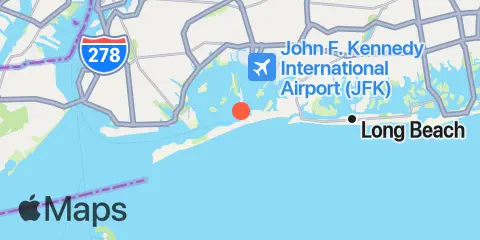
Location & Map
Latitude
40° 35' 18" N (40.5883)
Longitude
73° 49' 12" W (-73.82)
State
County
Nearby
Tides
3.1 mi
J.F.K. International Airport, Jamaica Bay
3.7 mi
Barren Island, Rockaway Inlet, Jamaica Bay
3.8 mi
Motts Basin, Jamaica Bay
4.0 mi
North Channel Bridge, Grassy Bay, Jamaica Bay
4.1 mi
Atlantic Beach, East Rockaway Inlet, Long Island
4.5 mi
Canarsie, Jamaica Bay
5.0 mi
Norton Point, Head of Bay, Jamaica Bay
5.5 mi
Mill Basin, Jamaica Bay
5.5 mi
Plumb Beach Channel, Jamaica Bay
6.0 mi
Kingsborough Community College, Sheepshead Bay, Long Island
6.8 mi
Woodmere, Brosewere Bay, Hempstead Bay
8.4 mi
Bay Park, East Rockaway, Hewlett Bay
8.7 mi
Coney Island
8.7 mi
Long Beach (Bridgeview Yacht Club)
9.0 mi
Long Beach (Inside), Hempstead Bay
9.4 mi
Norton Point, Gravesend Bay
11.1 mi
Parsonnage Cove, Long Island
11.4 mi
Fort Hamilton, The Narrows
11.4 mi
Gowanus Bay
11.5 mi
Wallabout Bay, Brooklyn Navy Yard, East River
11.5 mi
Williamsburg Bridge, East River
12.1 mi
Brooklyn Bridge, East River
12.4 mi
Point Lookout, Long Island
Currents
0.4 mi
Beach Channel (bridge)
2.4 mi
Grass Hassock Channel
3.4 mi
East Rockaway Inlet
3.5 mi
Marine Parkway Bridge, Rockaway Inlet
4.2 mi
Canarsie (midchannel), Jamaica Bay
6.4 mi
Rockaway Inlet Entrance
7.3 mi
Rockaway Point
8.3 mi
Rockaway Inlet Jetty, 1 nm SW of
8.4 mi
Long Beach, inside, between bridges
9.5 mi
Ambrose Channel
10.0 mi
Coney Island Channel, west end
10.0 mi
Coney Island Lt., 1.5 miles SSE of
10.8 mi
Norton Point, WSW of
11.5 mi
Sandy Hook Channel, Front Range Light
11.5 mi
The Narrows
11.6 mi
Gowanus Bay Entrance
11.7 mi
Corlears Hook
12.2 mi
Red Hook Channel
12.4 mi
Brooklyn Bridge
Note: Tide predictions are an estimate and NOT FOR NAVIGATION.
We also offer free widgets if you want to add tide or solunar tables to your own site.