Palmer Johnson Shipyard Tides
Unfortunately, this tide station is no longer active, and predictions are no longer accurate.
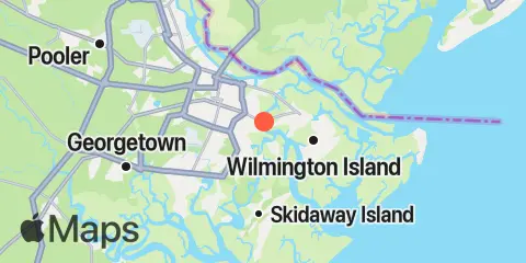
You can check out the map below -- any nearby locations will be displayed on the map and list below. Alternatively, you can browse the site for other active locations.
Location & Map
Latitude
32° 1' 24" N (32.0233)
Longitude
81° 2' 48" W (-81.0467)
State
County
Nearest ZIP
31404
Nearby
Tides
0.7 mi
Thunderbolt, Wilmington River
2.7 mi
Skidaway Institute, Skidaway River
2.8 mi
Isle of Hope, Skidaway River
3.2 mi
Savannah Sheraton Resort Hotel, Wilmington River
4.1 mi
North entrance, Wilmington River
4.1 mi
Fort Jackson, Savannah River
4.6 mi
Priest Landing, Wilmington River
4.8 mi
Savannah (Bull Street)
6.8 mi
Romerly Marsh Creek
7.3 mi
Vernon View, Burnside River
7.3 mi
Halfmoon Reef, Halfmoon River
7.5 mi
Turnbridge Landing, Salt Water Creek
8.0 mi
Fields Cut, Wright River
8.4 mi
Beach Hammock
8.6 mi
Fort Pulaski, Savannah River Entrance
8.7 mi
Coffee Bluff, Forest River
9.3 mi
Little Wassaw Island, Green Island Sound
10.0 mi
Port Wentworth, Savannah River
10.1 mi
Hargray Pier, Daufuskie Island, New River
10.4 mi
Doughboy Island, New River
10.5 mi
Daufuskie Landing, Daufuskie Island, New River
10.7 mi
Bloody Point, Daufuskie Island, New River
10.9 mi
Little Back River, Hwy. 17, Back River, Savannah River
11.0 mi
Pine Island, Ramshorn Creek, Cooper River
11.2 mi
Tybee Light, Savannah River
11.6 mi
Good Hope Landing, south of, New River
11.9 mi
Tybee Creek entrance
12.2 mi
Cook Landing Cemetery, New River
Currents
0.1 mi
Thunderbolt, SE of, Wilmington River
2.0 mi
Skidaway River, north entrance
2.4 mi
Skidaway Island, N End, Wilmington River
2.7 mi
Dutch Island, SE of, Skidaway River
2.8 mi
Wilmington R., 0.5 mi. S of Turners Creek
3.0 mi
Isle of Hope City, Skidaway River
3.2 mi
Isle of Hope City, SE of, Skidaway River
3.8 mi
Burntpot Island, west of, Skidaway River
4.1 mi
Oatland Island, north tip
4.3 mi
Fig Island, north of, Back River
4.5 mi
Wilmington R. ent., south channel
4.5 mi
McQueen Island Cut
4.7 mi
Long Island, NNE of, Skidaway River
4.7 mi
Savannah
4.8 mi
South Channel, western end
5.0 mi
Skidaway Narrows
5.2 mi
Elba Island, west of, Savannah River
5.3 mi
Savannah, southeast of highway bridge
5.4 mi
Fort Pulaski, 4.8 miles above
5.6 mi
Elba Island, NE of, Savannah River
5.7 mi
Long Island, south of, Skidaway River
5.9 mi
Elba Island Cut, NE of, Savannah River
6.2 mi
Pigeon Island, SSE of, Skidaway River
6.3 mi
Bull River, 2 miles below hwy. bridge
6.6 mi
Joe's Cut, Wilmington River
6.9 mi
Fort Pulaski, 1.8 miles above
6.9 mi
Seaboard Coast Line Railroad
7.1 mi
Lazaretto Creek Entrance, N of, Bull River
7.2 mi
Wilmington River ent. off Cabbage Island
7.3 mi
Burnside Island, SE of, Burnside River
7.8 mi
Montgomery, Vernon River
7.9 mi
Wilmington Island, SSE of, Bull River
8.5 mi
Wright R., 0.2 mile above Walls Cut
8.6 mi
Fort Pulaski
8.6 mi
Walls Cut, Turtle Island
8.6 mi
King Island, west of
8.8 mi
Entrance, off Beach Hammock
8.9 mi
Kings Island Channel, Savannah River
9.2 mi
Vernon R., 1.2 miles S of Possum Point
9.2 mi
Little Ogeechee River Entrance, north of
9.2 mi
Savannah River Entrance (between jetties)
9.4 mi
Entrance, off Wassaw Island
9.8 mi
Little Ogeechee River Entrance
9.8 mi
Wassaw Island, N of E end, Wassaw Sound
10.1 mi
Port Wentworth, 0.2 mile above
10.2 mi
Daufuskie Landing Light, south of
10.4 mi
Bloody Pt., 0.5 mile west of, New River
10.6 mi
Little Wassaw Island, SW of
10.7 mi
Little Don Island, east of, Vernon River
10.8 mi
Bloody Pt., 0.5 mile north of, New River
11.1 mi
Odingsell River Entrance
11.2 mi
Raccoon Key
11.7 mi
Wassaw Island, SSW of
12.2 mi
Ramshorn Creek Light, E of, Cooper River