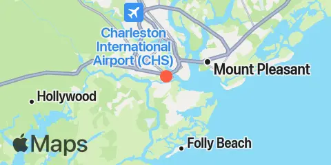
Check tides for fishing in Wappoo Creek, alongside major and minor solunar periods and a seven-day fishing outlook.

Daily fishing rating

90 / 100
Excellent

Solunar fishing outlook · About this rating

Major solunar periods

10:02 AM 12:02 PM

Low tide · 1:16 PM · 0.27 ft

10:27 PM 12:27 AM

Low tide · 1:08 AM · 0.15 ft

Based on solunar timing. Consider weather and water conditions.

Tides & fishing windows

Full tide details →

Shaded bands show major fishing periods. Fish markers show all major and minor periods.

Fishing times

Major Fishing Times

10:02 AM 12:02 PM

10:27 PM 12:27 AM

Minor Fishing Times

5:31 AM 6:31 AM

3:30 PM 4:30 PM

About Solunar Theory →

Tide Times & Heights

Wappoo Creek, South Carolina — Tide predictions for Monday, December 7, 2026. Local times: UTC−05:00. Heights in ft relative to MLLW.
Tide Time Height
Low tide 0.14′
High tide 5.86′
Low tide 0.27′
High tide 4.75′

Weather & marine conditions

Monday, December 7, 2026

Forecast unavailable for this selection.

Atmospheric pressure

Pressure forecasts are currently unavailable for this date.

Sun & moon

Moon phase

Waning Crescent Waning Crescent 2% illuminated

Sun & moon

Sunrise
Sunset
Moonrise
Moonset

7-day fishing planner

Daily ratings, all major and minor fishing periods, and tide times and heights.

Fishing planner for Wappoo Creek. Local times
DayRating / 100 Major Fishing TimesMinor Fishing Times 1st Tide 2nd Tide 3rd Tide 4th Tide
90
10:02 AM - 12:02 PM
10:27 PM - 12:27 AM
5:31 AM - 6:31 AM
3:30 PM - 4:30 PM
0.14 ft
5.86 ft
0.27 ft
4.75 ft
96
10:53 AM - 12:53 PM
6:29 AM - 7:29 AM
4:15 PM - 5:15 PM
0.15 ft
5.83 ft
0.27 ft
4.72 ft
93
11:44 AM - 1:44 PM
11:19 PM - 1:19 AM
7:24 AM - 8:24 AM
5:06 PM - 6:06 PM
0.18 ft
5.75 ft
0.31 ft
4.66 ft
89
12:10 AM - 2:10 AM
12:35 PM - 2:35 PM
8:13 AM - 9:13 AM
6:00 PM - 7:00 PM
0.23 ft
5.63 ft
0.39 ft
4.57 ft
84
1:00 AM - 3:00 AM
1:25 PM - 3:25 PM
8:56 AM - 9:56 AM
6:57 PM - 7:57 PM
0.29 ft
5.49 ft
0.49 ft
4.48 ft
74
1:49 AM - 3:49 AM
2:12 PM - 4:12 PM
9:34 AM - 10:34 AM
7:55 PM - 8:55 PM
0.38 ft
5.33 ft
0.59 ft
4.4 ft
65
2:35 AM - 4:35 AM
2:57 PM - 4:57 PM
10:07 AM - 11:07 AM
8:53 PM - 9:53 PM
0.48 ft
5.17 ft
0.66 ft
4.35 ft
About the fishing rating

The rating provides a general outlook for potential fish activity based on solunar conditions. It does not include weather, water conditions, species, or local fishing reports. A higher rating is not a guarantee of a catch.

About Solunar Theory

Weather & Marine Forecast → · Full tide details →

Location & Map

Latitude
32° 46' 0" N (32.7667)
Longitude
79° 58' 24" W (-79.9733)
Nearest ZIP
29407

Nearby

Tides 1.5 mi South Ashley Bridge, Ashley River 1.7 mi Elliott Cut entrance, Stono River 2.1 mi James Island Creek, 1 mi. above ent., Ashley River 3.0 mi Charleston, Cooper River Entrance 4.4 mi Duck Island, Ashley River 4.5 mi Fort Johnson 4.8 mi Cosgrove Bridge, Ashley River 4.8 mi Shipyard Creek, 0.8 mile above entrance. 5.2 mi Sandblasters, Pennys Creek, Stono River 5.6 mi I-526 bridge, Ashley River 5.6 mi Pennys Creek, west entrance, Stono River 5.6 mi Shem Creek 5.7 mi Fort Sumter 5.7 mi Hobcaw Point, Wando River 6.5 mi Folly Creek, Hwy. 171 bridge 6.5 mi Abbapoola Creek entrance, Stono River 6.8 mi Clouter Creek, south entrance, Cooper River 6.8 mi The Cove, Fort Moultrie 7.3 mi Drayton, Bee's Ferry, Ashley River 7.4 mi Folly River Bridge, Folly Island 7.5 mi Folly River, north, Folly Island 7.7 mi Ben Sawyer Bridge, ICWW 7.8 mi Church Creek bridge, Wadmalaw River 7.8 mi Limehouse Bridge, Stono River 8.1 mi Sullivans Island (outer coast) 8.4 mi Folly Island (outer coast) 9.1 mi Snake Island, Stono River 9.2 mi Oak Branch, Bohicket Creek, North Edisto River 9.4 mi Breach Inlet, Isle of Palms 9.9 mi Clouter Creek, north entrance, Cooper River 9.9 mi Magnolia Gardens, Ashley River 10.0 mi Army Depot, Cooper River 10.2 mi Nowell Creek, Wando River 10.6 mi Hamlin Creek, Isle of Palms 10.7 mi Hanahan, Turkey Creek, Goose Creek, Cooper River 11.0 mi Yeamans Hall, Goose Creek, Cooper River 11.0 mi Isle of Palms Pier 11.1 mi Parker Island, Horlbeck Creek, Wando River 11.2 mi Hollywood, Stono River 11.4 mi Johns Island, Church Creek, Wadmalaw River 11.6 mi Hamlin Sound

About these predictions

Tide heights are predictions, not measurements. Wind, air pressure, storms, and river flow can cause actual water levels to differ. Not for navigation.

Tide prediction source: Tide predictions: NOAA Center for Operational Oceanographic Products and Services (CO-OPS). Official source
Vertical datum: MLLW — Mean Lower Low Water