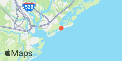
Isle Of Palms Pier Weekly Tide Tables and Charts
Tide Chart for Next 7 Days
About this chart
Isle Of Palms Pier weekly tide chart key:
The tide chart above shows the times and heights of high tide and low tide for Isle Of Palms Pier, for the next seven days. The red line highlights the current time and estimated height.The tidal range at Isle Of Palms Pier from through is approximately 6.4 ft, with a minimum tide of -0.01 ft and maximum tide of 6.39 ft. You can also check out all the daily details on tides & fishing times on the Day tab for Isle Of Palms Pier.
Tide Table for Next 7 Days
▲ Blue = High Tide
▼ Red = Low Tide
| Day | Moon phase | 1st Tide | 2nd Tide | 3rd Tide | 4th Tide | ☀ Sun |
Major Times

|
Minor Times

|
|---|---|---|---|---|---|---|---|---|
 89% |
▼ -0.01 ft |
▲ 6.39 ft |
▼ 0.51 ft |
▲ 5.06 ft |
▲ 7:34 AM ▼ 6:31 PM |
2:58 AM → 4:58 AM 3:29 PM → 5:29 PM |
11:04 AM → 12:04 PM 8:55 PM → 9:55 PM |
|
|
81%
|
▼ 0.15 ft |
▲ 6.2 ft |
▼ 0.67 ft |
▲ 7:35 AM ▼ 6:30 PM |
4:02 AM → 6:02 AM 4:35 PM → 6:35 PM |
12:06 PM → 1:06 PM 10:04 PM → 11:04 PM |
||
|
71%
|
▲ 4.94 ft |
▼ 0.35 ft |
▲ 6 ft |
▼ 0.79 ft |
▲ 7:36 AM ▼ 6:29 PM |
5:04 AM → 7:04 AM 5:36 PM → 7:36 PM |
12:58 PM → 1:58 PM 11:15 PM → 12:15 AM |
|
 50% |
▲ 4.91 ft |
▼ 0.52 ft |
▲ 5.83 ft |
▼ 0.8 ft |
▲ 6:37 AM ▼ 5:28 PM |
5:02 AM → 7:02 AM 5:33 PM → 7:33 PM |
12:41 PM → 1:41 PM 11:25 PM → 12:25 AM |
|
 48% |
▲ 4.99 ft |
▼ 0.6 ft |
▲ 5.7 ft |
▼ 0.72 ft |
▲ 6:38 AM ▼ 5:27 PM |
5:55 AM → 7:55 AM 6:24 PM → 8:24 PM |
1:17 PM → 2:17 PM | |
|
37%
|
▲ 5.16 ft |
▼ 0.6 ft |
▲ 5.61 ft |
▼ 0.59 ft |
▲ 6:39 AM ▼ 5:26 PM |
6:44 AM → 8:44 AM 7:11 PM → 9:11 PM |
12:31 AM → 1:31 AM 1:48 PM → 2:48 PM |
|
|
27%
|
▲ 5.4 ft |
▼ 0.55 ft |
▲ 5.53 ft |
▼ 0.45 ft |
▲ 6:40 AM ▼ 5:25 PM |
7:30 AM → 9:30 AM 7:56 PM → 9:56 PM |
1:35 AM → 2:35 AM 2:17 PM → 3:17 PM |
Location & Map
Latitude
32° 46' 60" N (32.7833)
Longitude
79° 47' 6" W (-79.785)
State
County
Nearest ZIP
29451
Nearby
Tides
0.5 mi
Hamlin Creek, Isle of Palms
1.6 mi
Breach Inlet, Isle of Palms
3.0 mi
Hamlin Sound
3.0 mi
Sullivans Island (outer coast)
3.4 mi
Ben Sawyer Bridge, ICWW
4.4 mi
The Cove, Fort Moultrie
4.8 mi
South Dewees Island, Dewees Inlet
5.7 mi
Shem Creek
5.7 mi
Fort Sumter
6.6 mi
North Dewees Island, Capers Inlet
6.8 mi
Capers Creek, South Capers Island
6.9 mi
Fort Johnson
7.2 mi
Hobcaw Point, Wando River
7.8 mi
Parker Island, Horlbeck Creek, Wando River
8.1 mi
Charleston, Cooper River Entrance
8.3 mi
Old Capers Landing, Santee Pass, Capers Island
9.4 mi
Big Paradise Island, Wando River
9.9 mi
James Island Creek, 1 mi. above ent., Ashley River
9.9 mi
Woodville, Wando River
10.0 mi
South Ashley Bridge, Ashley River
10.0 mi
Price Creek, North Capers Island
10.2 mi
Shipyard Creek, 0.8 mile above entrance.
10.3 mi
Cainhoy, Wando River
10.4 mi
Clouter Creek, south entrance, Cooper River
10.5 mi
Nowell Creek, Wando River
11.0 mi
Folly River, north, Folly Island
11.0 mi
Wappoo Creek, highway bridge, Ashley River
11.0 mi
Duck Island, Ashley River
12.2 mi
Clouter Creek, north entrance, Cooper River
12.3 mi
Folly Creek, Hwy. 171 bridge
12.3 mi
Cosgrove Bridge, Ashley River
Currents
4.3 mi
Fort Sumter Range, Buoy 18
4.5 mi
Charleston Hbr. ent. (between jetties)
4.6 mi
Fort Sumter Range, Buoy 22
4.6 mi
North Jetty, 0.8 mile southeast of
4.7 mi
Fort Sumter Range, Buoy 16
5.0 mi
Ft. Sumter, 0.6 n.mi. NW of
5.2 mi
The Cove, entrance on the Cove Range
5.2 mi
South Jetty, break in
5.3 mi
Rebellion Reach, 0.8 n.mi. N. of Ft. Sumter
5.3 mi
Charleston Harbor (off Fort Sumter)
5.3 mi
Hog Island Channel
6.0 mi
South Chan., 0.8 mi. ENE of Ft. Johnson
6.2 mi
Fort Sumter Range, Buoy 14
6.7 mi
Bennis Range, Buoy 31
6.8 mi
Folly I. Channel, N of Ft. Johnson
7.3 mi
South Chan., 0.4 mi. NW of Ft. Johnson
7.3 mi
Bennis Range, Buoy 34
7.4 mi
Wando River Upper Reach, Turning Basin
7.5 mi
Castle Pinckney, 0.4 mile south of
7.5 mi
South Channel, Buoy 4
7.6 mi
Horse Reach
7.6 mi
Remley Point, 0.2 mile northwest of
7.6 mi
Hog Island Reach, Buoy 38
7.6 mi
Hog Island Reach, SW of Remley Point
7.7 mi
Nowell Creek, Southeast of
7.7 mi
Drum Island, east of (bridge)
7.7 mi
Fort Sumter Range, Buoy 10
7.8 mi
Customhouse Reach
7.8 mi
Horlbeck Creek, 0.2 mile above entrance
7.9 mi
Castle Pinckney, 0.6 mile southwest of
7.9 mi
Shutes Folly Island, 0.4 mile west of
7.9 mi
Drum Island, 0.4 mile SSE of
8.0 mi
Customhouse Reach, off Customhouse
8.1 mi
Lower Town Creek Reach
8.3 mi
Drum Island Reach, marker 45
8.3 mi
Rathall Creek entrance
8.4 mi
Nowell Creek entrance
8.7 mi
Town Creek, 0.2 mile above bridge
8.7 mi
Battery, southwest of
8.7 mi
Drum Island, 0.2 mile above
8.9 mi
Daniel Island Reach, Buoy 48
9.1 mi
Daniel Island Reach, Buoy 47A
9.3 mi
Shipyard Creek entrance
9.5 mi
Daniel Island Bend
9.6 mi
Wappoo Creek entrance
9.8 mi
Anneville, marker 36
10.2 mi
Ashley River Memorial Bridge, Highway 17
10.8 mi
Duck Island, Marker 15
11.0 mi
Trestle Ruins, marker 6A
11.5 mi
North Charleston
12.0 mi
State Hwy. 7 bridge
12.4 mi
Yellow House Creek
About these predictions
Tide heights are predictions, not measurements. Wind, air pressure, storms, and river flow can cause actual water levels to differ. Not for navigation.
Tide prediction source:
NOAA
Vertical datum:
MLLW — Mean Lower Low Water
Add a free tide or fishing times widget for this station to your website.