Amelia City Weekly Tide Tables and Charts
Tide Chart for Next 7 Days
Amelia City weekly tide chart key:
The tide chart above shows the times and heights of high tide and low tide for Amelia City, for the next seven days. The red line highlights the current time and estimated height.The tidal range at Amelia City for the next seven days is approximately 5.57 ft with a minimum tide of 0.13 ft and maximum tide of 5.7 ft. You can also check out all the daily details on tides & fishing times on the Day tab for Amelia City.
Tide Table for Next 7 Days
▲ Blue = High Tide
▼ Red = Low Tide
| Day | 1st Tide | 2nd Tide | 3rd Tide | 4th Tide | ☀ Sun |
Major Solunars
|
Minor Solunars
|
|
|---|---|---|---|---|---|---|---|---|
| 30 Thu |
|
▼ 0.35 ft |
▲ 4.9 ft |
▼ 0.25 ft |
▲ 5.66 ft |
▲ 6:43 AM ▼ 8:22 PM |
1:03 AM → 3:03 AM 1:21 PM → 3:21 PM |
7:01 AM → 8:01 AM 8:42 PM → 9:42 PM |
| 31 Fri |
|
▼ 0.28 ft |
▲ 4.99 ft |
▼ 0.28 ft |
▲ 5.58 ft |
▲ 6:43 AM ▼ 8:21 PM |
1:48 AM → 3:48 AM 2:06 PM → 4:06 PM |
8:00 AM → 9:00 AM 9:12 PM → 10:12 PM |
| 1 Sat |
|
▼ 0.22 ft |
▲ 5.1 ft |
▼ 0.35 ft |
▲ 6:44 AM ▼ 8:20 PM |
2:31 AM → 4:31 AM 2:48 PM → 4:48 PM |
8:57 AM → 9:57 AM 9:40 PM → 10:40 PM |
|
| 2 Sun |
|
▲ 5.48 ft |
▼ 0.17 ft |
▲ 5.23 ft |
▼ 0.45 ft |
▲ 6:45 AM ▼ 8:19 PM |
3:14 AM → 5:14 AM 3:31 PM → 5:31 PM |
9:55 AM → 10:55 AM 10:08 PM → 11:08 PM |
| 3 Mon |
|
▲ 5.35 ft |
▼ 0.14 ft |
▲ 5.37 ft |
▼ 0.58 ft |
▲ 6:45 AM ▼ 8:19 PM |
3:57 AM → 5:57 AM 4:16 PM → 6:16 PM |
10:55 AM → 11:55 AM 10:37 PM → 11:37 PM |
| 4 Tue |
|
▲ 5.21 ft |
▼ 0.13 ft |
▲ 5.5 ft |
▼ 0.71 ft |
▲ 6:46 AM ▼ 8:18 PM |
4:43 AM → 6:43 AM 5:03 PM → 7:03 PM |
11:56 AM → 12:56 PM 11:10 PM → 12:10 AM |
| 5 Wed |
|
▲ 5.05 ft |
▼ 0.13 ft |
▲ 5.61 ft |
▼ 0.8 ft |
▲ 6:46 AM ▼ 8:17 PM |
5:32 AM → 7:32 AM 5:54 PM → 7:54 PM |
1:01 PM → 2:01 PM |
Buoy Weather
Air Temperature
81° F
Wind
7 knots W (280°)
Wind Gust
10 knots
Atmospheric Pressure
1014 hPa
Note: Observations are from a weather buoy 6.11 miles from the prediction site. Observations are not available at all prediction sites, and observation types vary between sites.
More details: Station frdf1 Buoy Weather
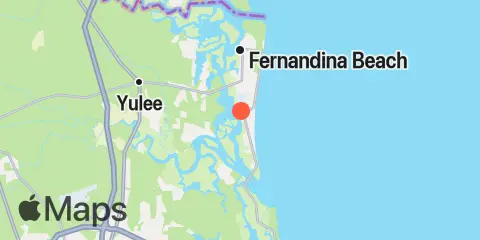
Location & Map
Latitude
30° 35' 12" N (30.5867)
Longitude
81° 27' 48" W (-81.4633)
State
County
Nearest ZIP
32034
Nearby
Tides
3.2 mi
Kingsley Creek, RR. bridge
3.3 mi
Nassauville, Nassau River East
4.8 mi
Nassau River entrance
5.1 mi
Sawpit Creek entrance, bridge
5.3 mi
Lofton, Lanceford Creek
5.8 mi
Sawpit Creek, 1 mi. above entrance
5.9 mi
Fernandina Beach, Amelia River
6.2 mi
Tiger Point, Pumpkin Hill Creek, Nassau River
6.5 mi
Cuno, Lofton Creek, Nassau River
7.4 mi
Vaughns Landing
7.5 mi
Edwards Creek, Nassau River
7.9 mi
Mink Creek entrance, Nassau River
7.9 mi
Chester, Bells River
8.4 mi
Cut 1N front range, St. Marys River
8.6 mi
Simpson Creek, A1A highway bridge
8.7 mi
Halfmoon Island, highway bridge, Nassau River
9.3 mi
St. Marys Entrance, North Jetty
9.7 mi
Beach Creek ent., Cumberland Island
10.3 mi
Fort George Island, Fort George River
10.5 mi
Roses Bluff, Bells River
10.5 mi
St. Marys, St. Marys River
11.4 mi
Little Talbot Island, Ocean
11.8 mi
Sisters Creek
11.9 mi
Boggy Creek, 2 mi. above entrance, Nassau River
12.2 mi
Dungeness, Seacamp Dock
Currents
3.2 mi
Kingsley Creek, highway bridge
3.5 mi
South Amelia River, off Walker Creek
3.8 mi
Nassau River, SW of Mesa Marsh
4.4 mi
Midsound, 1 mi. N of Sawpit Creek entrance
5.8 mi
Fernandina Beach, City Front Reach, Amelia River
6.9 mi
Old Fernandina, Amelia River, Old Town Reach
8.2 mi
Quarantine Reach, 0.4nm W of Fort Clinch
8.5 mi
St. Mary's River Entrance
8.5 mi
Fort Clinch, 1.1 n.mi. NW of
8.6 mi
Range A, LB 23, St Marys River
8.9 mi
St Marys Entrance, LB 19
9.0 mi
Ft. George River
9.2 mi
south jetty
9.6 mi
Range A2, LB 29, Cumberland Sound
10.1 mi
St Marys Entrance, LB 13
12.0 mi
Drum Point Island, Range D Channel
Note: Tide predictions are an estimate and NOT FOR NAVIGATION.
We also offer free widgets if you want to add tide or solunar tables to your own site.