Egg Islands Tides & Fishing Times
Tides
Egg Islands tide chart key:
The tide chart above shows the times and heights of high tide and low tide for Egg Islands, as well as solunar period times (represented by fish icons). The red line highlights the current time and estimated height.| Day | Time | Tide | Height | |
|---|---|---|---|---|
| 1 Sat | ▲ High | 7.42 ft | ||
| 2 Sun | ▼ Low | 0.16 ft | ||
| 2 Sun | ▲ High | 7.08 ft | ||
| 2 Sun | ▼ Low | 0.61 ft | ||
| 2 Sun | ▲ High | 7.24 ft | ||
| 3 Mon | ▼ Low | 0.12 ft |
Sunday, August 2, 2026 11:44 AM: The tide is currently falling at Egg Islands with a current estimated height of 6.9 ft. The last tide was High at 11:11 AM and the next tide is a Low of 0.61 ft at 5:41 PM. The tidal range today is approximately 7.08 ft with a minimum tide of 0.16 ft and maximum tide of 7.24 ft.
Next 7 Days
▲ Blue = High Tide
▼ Red = Low Tide
| Day | 1st Tide | 2nd Tide | 3rd Tide | 4th Tide | ☀ Sun |
Major Solunars
|
Minor Solunars
|
|
|---|---|---|---|---|---|---|---|---|
| 2 Sun |
|
▼ 0.16 ft |
▲ 7.08 ft |
▼ 0.61 ft |
▲ 7.24 ft |
▲ 6:41 AM ▼ 8:20 PM |
3:12 AM → 5:12 AM 3:30 PM → 5:30 PM |
9:54 AM → 10:54 AM 10:06 PM → 11:06 PM |
| 3 Mon |
|
▼ 0.12 ft |
▲ 7.25 ft |
▼ 0.78 ft |
▲ 6:41 AM ▼ 8:19 PM |
3:56 AM → 5:56 AM 4:14 PM → 6:14 PM |
10:54 AM → 11:54 AM 10:34 PM → 11:34 PM |
|
| 4 Tue |
|
▲ 7.04 ft |
▼ 0.13 ft |
▲ 7.43 ft |
▼ 0.97 ft |
▲ 6:42 AM ▼ 8:18 PM |
4:41 AM → 6:41 AM 5:01 PM → 7:01 PM |
11:56 AM → 12:56 PM 11:06 PM → 12:06 AM |
| 5 Wed |
|
▲ 6.84 ft |
▼ 0.17 ft |
▲ 7.62 ft |
▼ 1.13 ft |
▲ 6:43 AM ▼ 8:18 PM |
5:30 AM → 7:30 AM 5:52 PM → 7:52 PM |
1:02 PM → 2:02 PM |
| 6 Thu |
|
▲ 6.68 ft |
▼ 0.2 ft |
▲ 7.81 ft |
▼ 1.17 ft |
▲ 6:43 AM ▼ 8:17 PM |
6:23 AM → 8:23 AM 6:49 PM → 8:49 PM |
11:43 PM → 12:43 AM 2:10 PM → 3:10 PM |
| 7 Fri |
|
▲ 6.58 ft |
▼ 0.19 ft |
▲ 7.98 ft |
▼ 1.06 ft |
▲ 6:44 AM ▼ 8:16 PM |
7:21 AM → 9:21 AM 7:50 PM → 9:50 PM |
12:28 AM → 1:28 AM 3:20 PM → 4:20 PM |
| 8 Sat |
|
▲ 6.57 ft |
▼ 0.07 ft |
▲ 8.17 ft |
▼ 0.8 ft |
▲ 6:45 AM ▼ 8:15 PM |
8:24 AM → 10:24 AM 8:56 PM → 10:56 PM |
1:21 AM → 2:21 AM 4:28 PM → 5:28 PM |
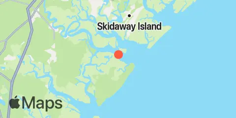
Location & Map
Latitude
31° 49' 60" N (31.83333)
Longitude
81° 4' 60" W (-81.08333)
State
County
Nearest ZIP
31411
Nearby
Tides
2.1 mi
Bradley Point, Bradley River
4.0 mi
Florida Passage, Ogeechee River
4.1 mi
Cane Patch Creek entrance
4.1 mi
Little Wassaw Island, Green Island Sound
5.0 mi
Florida Passage, Bear River
6.4 mi
Bear River, (Range 'A' Light)
6.5 mi
Vernon View, Burnside River
7.7 mi
Kilkenny Club, Kilkenny Creek
7.9 mi
Coffee Bluff, Forest River
8.4 mi
South Ossabaw Island, Bear River
8.5 mi
Romerly Marsh Creek
8.6 mi
Fort McAllister, Ogeechee River
9.9 mi
Priest Landing, Wilmington River
10.6 mi
Isle of Hope, Skidaway River
10.8 mi
Walburg Creek entrance
11.4 mi
Skidaway Institute, Skidaway River
11.9 mi
Beach Hammock
12.2 mi
Halfmoon Reef, Halfmoon River
12.3 mi
North Newport River (Daymark 119)
12.4 mi
Sunbury, Sunbury Channel
Currents
1.1 mi
Raccoon Key & Egg Island Shoal, between
2.6 mi
Raccoon Key
2.6 mi
Little Don Island, east of, Vernon River
2.6 mi
Bradley Point, NNE of
3.2 mi
Little Wassaw Island, SW of
3.9 mi
Florida Passage, N of, Ogeechee River
3.9 mi
Little Ogeechee River Entrance
4.4 mi
Florida Passage (south)
4.4 mi
Little Ogeechee River Entrance, north of
4.6 mi
Vernon R., 1.2 miles S of Possum Point
4.7 mi
Wassaw Island, SSW of
5.5 mi
Odingsell River Entrance
5.7 mi
North of Big Tom Creek Entrance
5.7 mi
610 Statute Mile Mark
6.1 mi
Burnside Island, SE of, Burnside River
7.2 mi
Pigeon Island, SSE of, Skidaway River
7.4 mi
South of Kilkenny Creek Entrance
7.5 mi
Montgomery, Vernon River
7.6 mi
Northwest of Newell Creek Entrance
7.6 mi
Long Island, south of, Skidaway River
8.4 mi
Skidaway Narrows
8.6 mi
Long Island, NNE of, Skidaway River
8.8 mi
St. Catherines Sound Entrance
9.5 mi
Burntpot Island, west of, Skidaway River
9.5 mi
Joe's Cut, Wilmington River
9.6 mi
Wilmington River ent. off Cabbage Island
9.9 mi
Entrance, off Wassaw Island
10.1 mi
Isle of Hope City, SE of, Skidaway River
10.2 mi
Medway River at Marsh Island
10.2 mi
Wassaw Island, N of E end, Wassaw Sound
10.3 mi
Isle of Hope City, Skidaway River
10.4 mi
Medway River, northwest of Cedar Point
11.6 mi
Dutch Island, SE of, Skidaway River
11.6 mi
N. Newport River, NE of Vandyke Creek
11.6 mi
Entrance, off Beach Hammock
Note: Tide predictions are an estimate and NOT FOR NAVIGATION.
We also offer free widgets if you want to add tide or solunar tables to your own site.