San Marino Island Tides & Fishing Times
Tides
San Marino Island tide chart key:
The tide chart above shows the times and heights of high tide and low tide for San Marino Island, as well as solunar period times (represented by fish icons). The red line highlights the current time and estimated height.| Day | Time | Tide | Height | |
|---|---|---|---|---|
| 1 Sat | ▼ Low | 0.09 ft | ||
| 2 Sun | ▲ High | 2.27 ft | ||
| 2 Sun | ▼ Low | 0.09 ft | ||
| 2 Sun | ▲ High | 2.22 ft | ||
| 2 Sun | ▼ Low | 0.17 ft | ||
| 3 Mon | ▲ High | 2.23 ft |
Sunday, August 2, 2026 11:48 AM: The tide is currently rising at San Marino Island with a current estimated height of 2.1 ft. The last tide was Low at 6:13 AM and the next tide is a High of 2.22 ft at 12:33 PM. The tidal range today is approximately 2.18 ft with a minimum tide of 0.09 ft and maximum tide of 2.27 ft.
Next 7 Days
▲ Blue = High Tide
▼ Red = Low Tide
| Day | 1st Tide | 2nd Tide | 3rd Tide | 4th Tide | ☀ Sun |
Major Solunars
|
Minor Solunars
|
|
|---|---|---|---|---|---|---|---|---|
| 2 Sun |
|
▲ 2.27 ft |
▼ 0.09 ft |
▲ 2.22 ft |
▼ 0.17 ft |
▲ 6:48 AM ▼ 8:06 PM |
3:09 AM → 5:09 AM 3:27 PM → 5:27 PM |
9:50 AM → 10:50 AM 10:04 PM → 11:04 PM |
| 3 Mon |
|
▲ 2.23 ft |
▼ 0.04 ft |
▲ 2.22 ft |
▼ 0.27 ft |
▲ 6:48 AM ▼ 8:05 PM |
3:52 AM → 5:52 AM 4:11 PM → 6:11 PM |
10:46 AM → 11:46 AM 10:36 PM → 11:36 PM |
| 4 Tue |
|
▲ 2.18 ft |
▼ 0.02 ft |
▲ 2.2 ft |
▼ 0.38 ft |
▲ 6:49 AM ▼ 8:05 PM |
4:37 AM → 6:37 AM 4:58 PM → 6:58 PM |
11:45 AM → 12:45 PM 11:12 PM → 12:12 AM |
| 5 Wed |
|
▲ 2.13 ft |
▼ 0.02 ft |
▲ 2.18 ft |
▼ 0.48 ft |
▲ 6:49 AM ▼ 8:04 PM |
5:26 AM → 7:26 AM 5:49 PM → 7:49 PM |
12:47 PM → 1:47 PM |
| 6 Thu |
|
▲ 2.09 ft |
▼ 0.02 ft |
▲ 2.16 ft |
▼ 0.55 ft |
▲ 6:49 AM ▼ 8:03 PM |
6:19 AM → 8:19 AM 6:45 PM → 8:45 PM |
11:52 PM → 12:52 AM 1:52 PM → 2:52 PM |
| 7 Fri |
|
▲ 2.07 ft |
▼ -0.01 ft |
▲ 2.18 ft |
▼ 0.55 ft |
▲ 6:50 AM ▼ 8:03 PM |
7:18 AM → 9:18 AM 7:47 PM → 9:47 PM |
12:39 AM → 1:39 AM 3:00 PM → 4:00 PM |
| 8 Sat |
|
▲ 2.1 ft |
▼ -0.06 ft |
▲ 2.26 ft |
▲ 6:50 AM ▼ 8:02 PM |
8:20 AM → 10:20 AM 8:52 PM → 10:52 PM |
1:35 AM → 2:35 AM 4:07 PM → 5:07 PM |
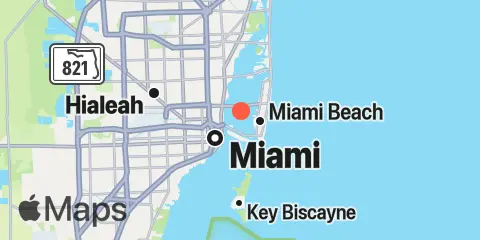
Location & Map
Latitude
25° 47' 36" N (25.7933)
Longitude
80° 9' 48" W (-80.1633)
State
County
Nearest ZIP
33139
Nearby
Tides
1.6 mi
Dodge Island, Fishermans Channel, Biscayne Bay
1.7 mi
Miami, Miamarina, Biscayne Bay
2.6 mi
Miami Beach (city pier)
2.9 mi
Government Cut, Miami Harbor Entrance
4.3 mi
Virginia Key, Bear Cut, Biscayne Bay
5.8 mi
Indian Creek Golf Club, ICWW
6.0 mi
Biscayne Creek, ICWW
6.5 mi
Dinner Key Marina, Biscayne Bay
6.6 mi
Key Biscayne Yacht Club, Biscayne Bay
8.0 mi
Bakers Haulover Inlet (Inside)
8.1 mi
Haulover Pier, N. Miami Beach
9.6 mi
Sunny Isles, Biscayne Creek
9.8 mi
Coral Shoal, Biscayne Channel
9.8 mi
North Miami Beach, Newport Fishing Pier
10.5 mi
Dumfoundling Bay
12.2 mi
Golden Beach, ICWW
Currents
1.3 mi
Dodge Island, SE Turning Basin
1.4 mi
Dodge Island, NW Turning Basin
1.4 mi
Main Ship Channel
1.7 mi
Dodge Island Cut, west end
1.8 mi
Lummus Island Turning Basin
2.0 mi
Lummus Island, SW corner
2.1 mi
Norris Cut
2.2 mi
Fisher Island Turning Basin
2.2 mi
Miami River Entrance
2.2 mi
Pilot House
2.6 mi
West entrance, south side
2.7 mi
Miami Harbor Entrance
3.2 mi
South Jetty
7.8 mi
Bakers Haulover Cut
Note: Tide predictions are an estimate and NOT FOR NAVIGATION.
We also offer free widgets if you want to add tide or solunar tables to your own site.