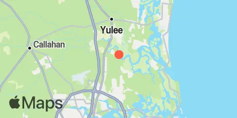
Mink Creek Entrance Map
Latitude
30° 32' 12" N (30.5367)
Longitude
81° 34' 54" W (-81.5817)
State
County
Nearest ZIP
32226
Nearby
Tides
2.8 mi
Cuno, Lofton Creek, Nassau River
3.2 mi
Halfmoon Island, highway bridge, Nassau River
3.4 mi
Edwards Creek, Nassau River
4.5 mi
Nassauville, Nassau River East
5.7 mi
Tiger Point, Pumpkin Hill Creek, Nassau River
6.0 mi
Boggy Creek, 2 mi. above entrance, Nassau River
6.5 mi
Vaughns Landing
6.9 mi
Sawpit Creek, 1 mi. above entrance
7.6 mi
Sawpit Creek entrance, bridge
7.8 mi
Nassau River entrance
7.8 mi
Cedar Heights, Broward River
7.9 mi
Amelia City, South Amelia River
8.2 mi
Lofton, Lanceford Creek
8.8 mi
Blount Island Bridge
9.1 mi
Kingsley Creek, RR. bridge
9.8 mi
Jacksonville, Navy Fuel Depot
10.0 mi
Clapboard Creek, Pelotes Island
10.2 mi
Simpson Creek, A1A highway bridge
10.5 mi
Dame Point, St. Johns River
10.5 mi
Chester, Bells River
10.9 mi
Fort George Island, Fort George River
11.1 mi
Fulton
11.1 mi
Phoenix Park
11.1 mi
Moncrief Creek entrance, Trout River
11.3 mi
Sisters Creek
11.5 mi
Roses Bluff, Bells River
11.6 mi
Fernandina Beach, Amelia River
11.8 mi
Lake Forest, Ribault River, Trout River
11.9 mi
Sherwood Forest, Trout River
Currents
6.1 mi
Nassau River, SW of Mesa Marsh
7.0 mi
South Amelia River, off Walker Creek
7.8 mi
Midsound, 1 mi. N of Sawpit Creek entrance
8.6 mi
Kingsley Creek, highway bridge
8.9 mi
Drummond Point, channel south of
9.5 mi
Ft. George River
10.4 mi
Reddie Point
10.5 mi
Dames Point Bridge
10.5 mi
Dames Point, 0.23 n.mi. ESE of
10.9 mi
Blount Island, East of
10.9 mi
Trout River Cut
11.3 mi
Chaseville Turn
11.3 mi
St. Johns Bluff
11.5 mi
Fernandina Beach, City Front Reach, Amelia River
12.4 mi
Sisters Creek entrance (bridge)