Crisfield Tides & Fishing Times
Tides
Crisfield tide chart key:
The tide chart above shows the times and heights of high tide and low tide for Crisfield, as well as solunar period times (represented by fish icons). The red line highlights the current time and estimated height.| Day | Time | Tide | Height | |
|---|---|---|---|---|
| 2 Sun | ▼ Low | 0.05 ft | ||
| 3 Mon | ▲ High | 2.05 ft | ||
| 3 Mon | ▼ Low | 0.04 ft | ||
| 3 Mon | ▲ High | 1.99 ft | ||
| 3 Mon | ▼ Low | 0.1 ft | ||
| 4 Tue | ▲ High | 1.93 ft |
Monday, August 3, 2026 6:56 AM: The tide is currently falling at Crisfield with a current estimated height of 1.3 ft. The last tide was High at 4:12 AM and the next tide is a Low of 0.04 ft at 10:39 AM. The tidal range today is approximately 2.01 ft with a minimum tide of 0.04 ft and maximum tide of 2.05 ft.
Next 7 Days
▲ Blue = High Tide
▼ Red = Low Tide
| Day | 1st Tide | 2nd Tide | 3rd Tide | 4th Tide | ☀ Sun |
Major Solunars
|
Minor Solunars
|
|
|---|---|---|---|---|---|---|---|---|
| 3 Mon |
|
▲ 2.05 ft |
▼ 0.04 ft |
▲ 1.99 ft |
▼ 0.1 ft |
▲ 6:08 AM ▼ 8:10 PM |
3:34 AM → 5:34 AM 3:52 PM → 5:52 PM |
10:37 AM → 11:37 AM 10:07 PM → 11:07 PM |
| 4 Tue |
|
▲ 1.93 ft |
▼ 0.04 ft |
▲ 2.05 ft |
▲ 6:09 AM ▼ 8:09 PM |
4:20 AM → 6:20 AM 4:38 PM → 6:38 PM |
11:43 AM → 12:43 PM 10:34 PM → 11:34 PM |
|
| 5 Wed |
|
▼ 0.17 ft |
▲ 1.78 ft |
▼ 0.05 ft |
▲ 2.08 ft |
▲ 6:10 AM ▼ 8:08 PM |
5:08 AM → 7:08 AM 5:30 PM → 7:30 PM |
12:53 PM → 1:53 PM 11:07 PM → 12:07 AM |
| 6 Thu |
|
▼ 0.22 ft |
▲ 1.64 ft |
▼ 0.07 ft |
▲ 2.13 ft |
▲ 6:11 AM ▼ 8:07 PM |
6:02 AM → 8:02 AM 6:26 PM → 8:26 PM |
2:05 PM → 3:05 PM |
| 7 Fri |
|
▼ 0.25 ft |
▲ 1.54 ft |
▼ 0.07 ft |
▲ 2.19 ft |
▲ 6:12 AM ▼ 8:06 PM |
7:00 AM → 9:00 AM 7:28 PM → 9:28 PM |
11:47 PM → 12:47 AM 3:18 PM → 4:18 PM |
| 8 Sat |
|
▼ 0.23 ft |
▲ 1.48 ft |
▼ 0.04 ft |
▲ 2.25 ft |
▲ 6:13 AM ▼ 8:05 PM |
8:02 AM → 10:02 AM 8:34 PM → 10:34 PM |
12:38 AM → 1:38 AM 4:28 PM → 5:28 PM |
| 9 Sun |
|
▼ 0.18 ft |
▲ 1.49 ft |
▼ -0.02 ft |
▲ 2.31 ft |
▲ 6:13 AM ▼ 8:04 PM |
9:07 AM → 11:07 AM 9:41 PM → 11:41 PM |
1:40 AM → 2:40 AM 5:30 PM → 6:30 PM |
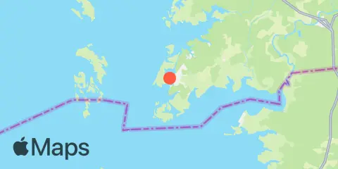
Location & Map
Latitude
37° 58' 36" N (37.9767)
Longitude
75° 51' 48" W (-75.8633)
State
County
Nearest ZIP
21817
Nearby
Tides
2.5 mi
Ape Hole Creek, Pocomoke Sound, Chesapeake Bay
5.9 mi
Colburn Creek, Big Annemessex River, Chesapeake Bay
6.4 mi
Long Point, Big Annemessex River, Chesapeake Bay
8.3 mi
Saxis, Starling Creek, Pocomoke Sound, Chesapeake Bay
9.2 mi
Teague Creek, Manokin River, Chesapeake Bay
9.3 mi
Ewell, Smith Island, Chesapeake Bay
12.3 mi
Shelltown, Pocomoke River
Currents
3.0 mi
Janes Island Light, 2.3 n.mi. NNE OF
5.0 mi
Big Annemessex River Entrance
5.5 mi
Long Point, 2.0 n.mi. northeast of
7.0 mi
Clump Island, 2.5 n.mi. west of
8.5 mi
Manokin R. Ent., 1.1 n.mi. E of Drum Pt
10.8 mi
Kedges Strait Buoy '4'
11.9 mi
Smith Point Light, 6.7 n.mi. east of
11.9 mi
Pocomoke R., 0.5 mile below Shelltown
Note: Tide predictions are an estimate and NOT FOR NAVIGATION.
We also offer free widgets if you want to add tide or solunar tables to your own site.