Mill Point Tides & Fishing Times
Tides
Mill Point tide chart key:
The tide chart above shows the times and heights of high tide and low tide for Mill Point, as well as solunar period times (represented by fish icons). The red line highlights the current time and estimated height.| Day | Time | Tide | Height | |
|---|---|---|---|---|
| 31 Fri | ▼ Low | 0.93 ft | ||
| 1 Sat | ▲ High | 9.59 ft | ||
| 1 Sat | ▼ Low | 0.03 ft | ||
| 1 Sat | ▲ High | 8.86 ft | ||
| 1 Sat | ▼ Low | 0.76 ft | ||
| 2 Sun | ▲ High | 9.5 ft |
Saturday, August 1, 2026 9:58 PM: The tide is currently rising at Mill Point with a current estimated height of 2.1 ft. The last tide was Low at 8:28 PM and the next tide is a High of 9.5 ft at 2:31 AM. The tidal range today is approximately 9.56 ft with a minimum tide of 0.03 ft and maximum tide of 9.59 ft.
Next 7 Days
▲ Blue = High Tide
▼ Red = Low Tide
| Day | 1st Tide | 2nd Tide | 3rd Tide | 4th Tide | ☀ Sun |
Major Solunars
|
Minor Solunars
|
|
|---|---|---|---|---|---|---|---|---|
| 1 Sat |
|
▲ 9.59 ft |
▼ 0.03 ft |
▲ 8.86 ft |
▼ 0.76 ft |
▲ 5:28 AM ▼ 8:02 PM |
1:43 AM → 3:43 AM 1:58 PM → 3:58 PM |
8:00 AM → 9:00 AM 8:56 PM → 9:56 PM |
| 2 Sun |
|
▲ 9.5 ft |
▼ 0.03 ft |
▲ 9.1 ft |
▼ 0.61 ft |
▲ 5:29 AM ▼ 8:01 PM |
2:26 AM → 4:26 AM 2:40 PM → 4:40 PM |
9:07 AM → 10:07 AM 9:14 PM → 10:14 PM |
| 3 Mon |
|
▲ 9.33 ft |
▼ 0.1 ft |
▲ 9.31 ft |
▼ 0.5 ft |
▲ 5:30 AM ▼ --:-- |
3:09 AM → 5:09 AM 3:25 PM → 5:25 PM |
10:16 AM → 11:16 AM 9:34 PM → 10:34 PM |
| 4 Tue |
|
▲ 9.09 ft |
▼ 0.25 ft |
▲ 9.49 ft |
▼ 0.43 ft |
▲ 5:31 AM ▼ 7:59 PM |
3:55 AM → 5:55 AM 4:12 PM → 6:12 PM |
11:28 AM → 12:28 PM 9:57 PM → 10:57 PM |
| 5 Wed |
|
▲ 8.81 ft |
▼ 0.45 ft |
▲ 9.61 ft |
▼ 0.39 ft |
▲ 5:32 AM ▼ 7:57 PM |
4:43 AM → 6:43 AM 5:03 PM → 7:03 PM |
12:42 PM → 1:42 PM 10:25 PM → 11:25 PM |
| 6 Thu |
|
▲ 8.52 ft |
▼ 0.67 ft |
▲ 9.69 ft |
▲ 5:33 AM ▼ 7:56 PM |
5:36 AM → 7:36 AM 6:00 PM → 8:00 PM |
1:59 PM → 2:59 PM 11:01 PM → 12:01 AM |
|
| 7 Fri |
|
▼ 0.38 ft |
▲ 8.27 ft |
▼ 0.86 ft |
▲ 9.76 ft |
▲ 5:34 AM ▼ 7:55 PM |
6:34 AM → 8:34 AM 7:02 PM → 9:02 PM |
3:16 PM → 4:16 PM |
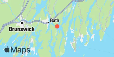
Location & Map
Latitude
43° 53' 12" N (43.8867)
Longitude
69° 45' 48" W (-69.7633)
State
County
Nearest ZIP
04530
Nearby
Tides
2.8 mi
Robinhood, Sasanoa River, Sheepscot River
3.7 mi
Bath, Kennebec River
4.2 mi
Isle of Springs, Sheepscot River
5.3 mi
Phippsburg, Kennebec River
5.4 mi
Cross River entrance, Sheepscot River
5.8 mi
Southport, Townsend Gut
6.0 mi
Howard Point, New Meadows River, Casco Bay
6.4 mi
Back River, Sheepscot River
7.2 mi
Boothbay Harbor
7.5 mi
Sturgeon Island, Merrymeeting Bay, Kennebec River
7.6 mi
Androscoggin River entrance, Kennebec River
9.1 mi
East Boothbay, Damariscotta River
9.2 mi
Fort Popham, Hunniwell Point, Kennebec River
9.2 mi
Wiscasset, Sheepscot River
9.4 mi
Cundy Harbor, New Meadows River, Casco Bay
9.7 mi
Walpole, Damariscotta River
10.3 mi
Brunswick, Androscoggin River, Kennebec River
10.7 mi
Bowdoinham, Cathance River, Kennebec River
11.5 mi
Wilson Cove, Middle Bay, Casco Bay
11.6 mi
Damariscove Harbor, Damariscove Island
11.9 mi
Pemaquid Harbor, Johns Bay
Currents
0.7 mi
Upper Hell Gate, Sasanoa River
1.7 mi
Fiddler Ledge, north of
1.8 mi
Lower Hell Gate, Knubble Bay
2.2 mi
Doubling Point, south of
2.4 mi
Lincoln Ledge, east of
2.6 mi
Bath Iron Works, Kennebec River
2.8 mi
Bluff Head, west of
3.2 mi
Lowe Point, NE of, Sasanoa River
3.7 mi
Sheepscot River, off Barter Island
6.1 mi
Bald Head, 0.3 mile southwest of
6.9 mi
Goose Cove, south of Chops Passage, Kennebec River
7.7 mi
Merrymeeting Bay, N of Chops Pass., Kennebec River
9.0 mi
Damariscotta River, off Cavis Point
9.0 mi
Hunniwell Point, northeast of
Note: Tide predictions are an estimate and NOT FOR NAVIGATION.
We also offer free widgets if you want to add tide or solunar tables to your own site.