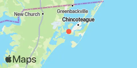
Southern Chincoteague Island Map
Latitude
37° 54' 9" N (37.9024)
Longitude
75° 24' 28" W (-75.4079)
State
County
Nearest ZIP
23336
Nearby
Tides
0.3 mi
Chincoteague Channel (South End), Chincoteague Bay
2.4 mi
Chincoteague Island, USCG station
3.1 mi
Chincoteague Island, Lewis Creek
3.4 mi
Assateague Beach, Toms Cove
4.3 mi
Chincoteague Island, Oyster Bay
4.5 mi
Chincoteague Island, Blake Cove
4.8 mi
Wishart Point, Bogues Bay
5.7 mi
Wallops Island
7.4 mi
Franklin City
8.0 mi
Jesters Island
12.1 mi
Gargathy Neck