Silver Eel Pond Tides & Fishing Times
Tides
Silver Eel Pond tide chart key:
The tide chart above shows the times and heights of high tide and low tide for Silver Eel Pond, as well as solunar period times (represented by fish icons). The red line highlights the current time and estimated height.| Day | Time | Tide | Height | |
|---|---|---|---|---|
| 2 Sun | ▼ Low | 0.51 ft | ||
| 3 Mon | ▲ High | 2.44 ft | ||
| 3 Mon | ▼ Low | 0.36 ft | ||
| 3 Mon | ▲ High | 2.72 ft | ||
| 3 Mon | ▼ Low | 0.48 ft | ||
| 4 Tue | ▲ High | 2.33 ft |
Monday, August 3, 2026 4:57 AM: The tide is currently falling at Silver Eel Pond with a current estimated height of 1.1 ft. The last tide was High at 1:06 AM and the next tide is a Low of 0.36 ft at 7:31 AM. The tidal range today is approximately 2.36 ft with a minimum tide of 0.36 ft and maximum tide of 2.72 ft.
Next 7 Days
▲ Blue = High Tide
▼ Red = Low Tide
| Day | 1st Tide | 2nd Tide | 3rd Tide | 4th Tide | ☀ Sun |
Major Solunars
|
Minor Solunars
|
|
|---|---|---|---|---|---|---|---|---|
| 3 Mon |
|
▲ 2.44 ft |
▼ 0.36 ft |
▲ 2.72 ft |
▼ 0.48 ft |
▲ 5:45 AM ▼ 8:03 PM |
3:19 AM → 5:19 AM 3:35 PM → 5:35 PM |
10:24 AM → 11:24 AM 9:47 PM → 10:47 PM |
| 4 Tue |
|
▲ 2.33 ft |
▼ 0.42 ft |
▲ 2.78 ft |
▼ 0.44 ft |
▲ 5:46 AM ▼ 8:01 PM |
4:04 AM → 6:04 AM 4:22 PM → 6:22 PM |
11:33 AM → 12:33 PM 10:12 PM → 11:12 PM |
| 5 Wed |
|
▲ 2.21 ft |
▼ 0.5 ft |
▲ 2.82 ft |
▼ 0.4 ft |
▲ 5:47 AM ▼ 8:00 PM |
4:53 AM → 6:53 AM 5:13 PM → 7:13 PM |
12:45 PM → 1:45 PM 10:42 PM → 11:42 PM |
| 6 Thu |
|
▲ 2.1 ft |
▼ 0.56 ft |
▲ 2.88 ft |
▼ 0.34 ft |
▲ 5:48 AM ▼ --:-- |
5:46 AM → 7:46 AM 6:10 PM → 8:10 PM |
2:00 PM → 3:00 PM 11:20 PM → 12:20 AM |
| 7 Fri |
|
▲ 2.03 ft |
▼ 0.58 ft |
▲ 2.97 ft |
▲ 5:49 AM ▼ 7:58 PM |
6:44 AM → 8:44 AM 7:11 PM → 9:11 PM |
3:14 PM → 4:14 PM | |
| 8 Sat |
|
▼ 0.24 ft |
▲ 2.06 ft |
▼ 0.54 ft |
▲ 3.09 ft |
▲ 5:50 AM ▼ 7:56 PM |
7:46 AM → 9:46 AM 8:17 PM → 10:17 PM |
12:09 AM → 1:09 AM 4:25 PM → 5:25 PM |
| 9 Sun |
|
▼ 0.13 ft |
▲ 2.14 ft |
▼ 0.45 ft |
▲ 3.2 ft |
▲ 5:51 AM ▼ 7:55 PM |
8:51 AM → 10:51 AM 9:25 PM → 11:25 PM |
1:10 AM → 2:10 AM 5:27 PM → 6:27 PM |
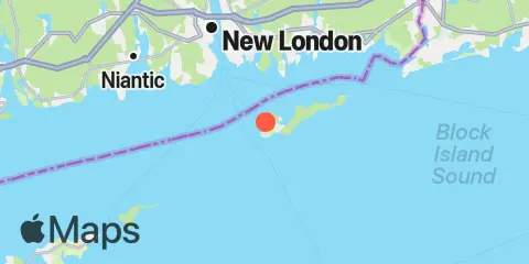
Location & Map
Latitude
41° 15' 24" N (41.2567)
Longitude
72° 1' 48" W (-72.03)
State
County
Nearest ZIP
06390
Nearby
Tides
5.1 mi
Little Gull Island, Long Island
6.6 mi
West Mystic, Mystic River, Long Island Sound
7.9 mi
New London, Thames River
9.4 mi
Niantic, Niantic River
9.4 mi
Watch Hill Point
10.8 mi
Plum Gut Harbor, Plum Island, Long Island
Currents
1.1 mi
Race Point, 0.4 mile southwest of
1.9 mi
Mt. Prospect, 0.6 mile SSE of
2.5 mi
North Hill Point, 1.1 miles NNW of
2.6 mi
The Race
3.6 mi
Thames River Approach
3.9 mi
Little Gull Island, 1.4 n.mi. NNE of
3.9 mi
Little Gull Island, 1.1 miles ENE of
4.0 mi
Goshen Point, 1.9 miles SSE of
4.0 mi
Clay Point, 1.3 miles NNE of
4.2 mi
Ram Island Reef, south of
4.3 mi
Cerberus Shoal and Fishers I., between
5.1 mi
New London Harbor entrance
5.2 mi
Little Gull Island, 0.8 mile NNW of
5.4 mi
Bartlett Reef, 0.2 mile south of
5.9 mi
East Pt., 4.1 miles S of Fishers Island
6.5 mi
Twotree Island Channel
6.8 mi
Fort Trumbull State Park
6.9 mi
Great Gull Island, SW of
7.3 mi
Wicopesset island, NE of
7.4 mi
Napatree Point, 0.7 mile southwest of
7.6 mi
New London State Pier
8.0 mi
Plum Island, 3nm. North of, Buoy PI
8.1 mi
Cerberus Shoal, 1.5 miles east of
8.6 mi
Gardiners Island, 3 miles northeast of
8.7 mi
U.S. Coast Guard Academy
9.0 mi
Niantic (Railroad Bridge)
9.1 mi
Gardiners Pt. Ruins, 1.1 miles N of
9.2 mi
Black Point and Plum Island, between
9.3 mi
Little Narragansett Bay entrance
9.3 mi
Black Point, 0.8 mile south of
9.6 mi
Plum Island, 0.8 mile NNW of
9.7 mi
Gardiners Point & Plum Island, between
9.8 mi
Eastern Plain Pt., 3.9 miles ENE of
9.9 mi
Groton, Thames River, Pier 6
10.2 mi
Shagwong Reef & Cerberus Shoal, between
10.3 mi
Smith Cove
11.4 mi
Watch Hill Point, 5.2 miles SSE of
11.4 mi
Plum Gut
11.8 mi
Hatchett Point, 1.6 n.mi. S of
11.9 mi
Watch Hill Point, 2.2 miles east of
Note: Tide predictions are an estimate and NOT FOR NAVIGATION.
We also offer free widgets if you want to add tide or solunar tables to your own site.