Vallenar Point Tides & Fishing Times
Tides
Vallenar Point tide chart key:
The tide chart above shows the times and heights of high tide and low tide for Vallenar Point, as well as solunar period times (represented by fish icons). The red line highlights the current time and estimated height.| Day | Time | Tide | Height | |
|---|---|---|---|---|
| 1 Sat | ▼ Low | 1.6 ft | ||
| 2 Sun | ▲ High | 14.92 ft | ||
| 2 Sun | ▼ Low | -0.68 ft | ||
| 2 Sun | ▲ High | 14.92 ft | ||
| 2 Sun | ▼ Low | 1.42 ft | ||
| 3 Mon | ▲ High | 14.11 ft |
Sunday, August 2, 2026 7:44 AM: The tide is currently falling at Vallenar Point with a current estimated height of 2.5 ft. The last tide was High at 3:25 AM and the next tide is a Low of -0.68 ft at 9:31 AM. The tidal range today is approximately 15.6 ft with a minimum tide of -0.68 ft and maximum tide of 14.92 ft.
Next 7 Days
▲ Blue = High Tide
▼ Red = Low Tide
| Day | 1st Tide | 2nd Tide | 3rd Tide | 4th Tide | ☀ Sun |
Major Solunars
|
Minor Solunars
|
|
|---|---|---|---|---|---|---|---|---|
| 2 Sun |
|
▲ 14.92 ft |
▼ -0.68 ft |
▲ 14.92 ft |
▼ 1.42 ft |
▲ 4:57 AM ▼ 8:49 PM |
2:41 AM → 4:41 AM 2:53 PM → 4:53 PM |
9:30 AM → 10:30 AM 9:17 PM → 10:17 PM |
| 3 Mon |
|
▲ 14.11 ft |
▼ 0.24 ft |
▲ 14.96 ft |
▼ 1.4 ft |
▲ 4:58 AM ▼ 8:47 PM |
3:25 AM → 5:25 AM 3:38 PM → 5:38 PM |
10:52 AM → 11:52 AM 9:24 PM → 10:24 PM |
| 4 Tue |
|
▲ 13.06 ft |
▼ 1.44 ft |
▲ 14.85 ft |
▼ 1.54 ft |
▲ 5:00 AM ▼ 8:45 PM |
4:11 AM → 6:11 AM 4:25 PM → 6:25 PM |
12:17 PM → 1:17 PM 9:34 PM → 10:34 PM |
| 5 Wed |
|
▲ 11.89 ft |
▼ 2.8 ft |
▲ 14.59 ft |
▲ 5:02 AM ▼ 8:43 PM |
5:00 AM → 7:00 AM 5:17 PM → 7:17 PM |
1:46 PM → 2:46 PM 9:48 PM → 10:48 PM |
|
| 6 Thu |
|
▼ 1.69 ft |
▲ 10.83 ft |
▼ 4.16 ft |
▲ 14.3 ft |
▲ 5:04 AM ▼ 8:41 PM |
5:54 AM → 7:54 AM 6:13 PM → 8:13 PM |
3:17 PM → 4:17 PM 10:10 PM → 11:10 PM |
| 7 Fri |
|
▼ 1.59 ft |
▲ 10.35 ft |
▼ 5.2 ft |
▲ 14.23 ft |
▲ 5:06 AM ▼ 8:39 PM |
6:53 AM → 8:53 AM 7:23 PM → 9:23 PM |
4:46 PM → 5:46 PM 10:47 PM → 11:47 PM |
| 8 Sat |
|
▼ 0.95 ft |
▲ 10.79 ft |
▼ 5.45 ft |
▲ 14.68 ft |
▲ 5:08 AM ▼ 8:37 PM |
7:56 AM → 9:56 AM 8:31 PM → 10:31 PM |
6:14 PM → 7:14 PM |
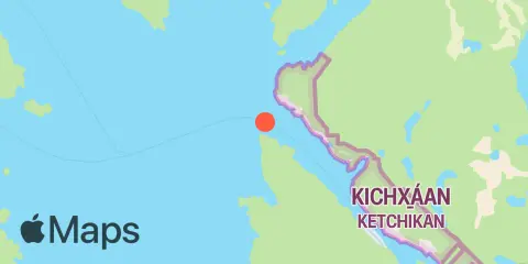
Location & Map
Latitude
55° 25' 36" N (55.4267)
Longitude
131° 50' 49" W (-131.847)
State
County
Nearest ZIP
99901
Nearby
Tides
5.1 mi
Ward Cove, Revillagigedo Channel
10.9 mi
Ketchikan, Tongass Narrows
Currents
3.5 mi
Guard Islands, 2 miles northwest of
4.4 mi
Guard Islands, 2 miles west of
6.3 mi
Guard Island Lighthouse, 5.1 miles SW of
7.7 mi
east of the airport
10.1 mi
Ketchikan
10.3 mi
Skin Island, 3 miles east from
11.0 mi
Grindall Island, south of
12.0 mi
Helm Point
12.3 mi
Saxman Spire, 0.2 mile south of
Note: Tide predictions are an estimate and NOT FOR NAVIGATION.
We also offer free widgets if you want to add tide or solunar tables to your own site.