Gravel Point Tides & Fishing Times
Tides
Gravel Point tide chart key:
The tide chart above shows the times and heights of high tide and low tide for Gravel Point, as well as solunar period times (represented by fish icons). The red line highlights the current time and estimated height.| Day | Time | Tide | Height | |
|---|---|---|---|---|
| 1 Sat | ▼ Low | 1.72 ft | ||
| 2 Sun | ▲ High | 11.93 ft | ||
| 2 Sun | ▼ Low | -0.53 ft | ||
| 2 Sun | ▲ High | 11.91 ft | ||
| 2 Sun | ▼ Low | 1.48 ft | ||
| 3 Mon | ▲ High | 11.17 ft |
Sunday, August 2, 2026 7:47 AM: The tide is currently falling at Gravel Point with a current estimated height of 4.9 ft. The last tide was High at 4:02 AM and the next tide is a Low of -0.53 ft at 10:57 AM. The tidal range today is approximately 12.46 ft with a minimum tide of -0.53 ft and maximum tide of 11.93 ft.
Next 7 Days
▲ Blue = High Tide
▼ Red = Low Tide
| Day | 1st Tide | 2nd Tide | 3rd Tide | 4th Tide | ☀ Sun |
Major Solunars
|
Minor Solunars
|
|
|---|---|---|---|---|---|---|---|---|
| 2 Sun |
|
▲ 11.93 ft |
▼ -0.53 ft |
▲ 11.91 ft |
▼ 1.48 ft |
▲ 5:25 AM ▼ 10:14 PM |
3:39 AM → 5:39 AM 3:49 PM → 5:49 PM |
10:32 AM → 11:32 AM 10:07 PM → 11:07 PM |
| 3 Mon |
|
▲ 11.17 ft |
▼ 0.35 ft |
▲ 12.06 ft |
▲ 5:27 AM ▼ 10:11 PM |
4:23 AM → 6:23 AM 4:34 PM → 6:34 PM |
12:02 PM → 1:02 PM 10:06 PM → 11:06 PM |
|
| 4 Tue |
|
▼ 1.36 ft |
▲ 10.2 ft |
▼ 1.45 ft |
▲ 12.1 ft |
▲ 5:30 AM ▼ 10:09 PM |
5:09 AM → 7:09 AM 5:21 PM → 7:21 PM |
1:37 PM → 2:37 PM 10:06 PM → 11:06 PM |
| 5 Wed |
|
▼ 1.38 ft |
▲ 9.12 ft |
▼ 2.68 ft |
▲ 12.03 ft |
▲ 5:32 AM ▼ 10:06 PM |
5:59 AM → 7:59 AM 6:19 PM → 8:19 PM |
3:16 PM → 4:16 PM 10:08 PM → 11:08 PM |
| 6 Thu |
|
▼ 1.46 ft |
▲ 8.26 ft |
▼ 3.89 ft |
▲ 11.95 ft |
▲ 5:34 AM ▼ 10:03 PM |
6:53 AM → 8:53 AM 7:18 PM → 9:18 PM |
5:22 PM → 6:22 PM 10:14 PM → 11:14 PM |
| 7 Fri |
|
▼ 1.42 ft |
▲ 8.05 ft |
▼ 4.87 ft |
▲ 12.06 ft |
▲ 5:37 AM ▼ 10:01 PM |
7:52 AM → 9:52 AM 8:21 PM → 10:21 PM |
7:11 PM → 8:11 PM 10:32 PM → 11:32 PM |
| 8 Sat |
|
▼ 0.96 ft |
▲ 8.51 ft |
▼ 5.23 ft |
▲ 12.47 ft |
▲ 5:39 AM ▼ 9:58 PM |
8:55 AM → 10:55 AM 9:31 PM → 11:31 PM |
8:32 PM → 9:32 PM |
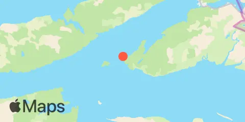
Location & Map
Latitude
60° 28' 0" N (60.46667)
Longitude
145° 58' 0" W (-145.96667)
State
County
Nearest ZIP
99574
Nearby
Tides
0.7 mi
Shag Rock, Orca Inlet
6.9 mi
Windy Bay, Hawkins Island, Prince William Sound
9.6 mi
Cordova, Orca Inlet, Prince William Sd
10.2 mi
Eyak River entrance
11.7 mi
Orca, Orca Inlet
Currents
7.0 mi
Mud Bay
10.4 mi
Channel Island
10.5 mi
Old Log Boom
11.8 mi
Salmo Point, Hawkins I., 1.2 miles SE of
12.3 mi
Salmo Point
Note: Tide predictions are an estimate and NOT FOR NAVIGATION.
We also offer free widgets if you want to add tide or solunar tables to your own site.