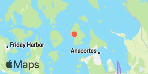
Strawberry Bay Tables et graphiques hebdomadaires des marées
Graphique des marées des 7 prochains jours
Légende du graphique hebdomadaire des marées de Strawberry Bay :
Le graphique indique les horaires et hauteurs des pleines et basses mers à Strawberry Bay pour les sept prochains jours. La ligne rouge indique l’heure actuelle et la hauteur estimée.Le marnage à Strawberry Bay pour les sept prochains jours est d’environ 8.92 ft, avec une hauteur minimale de -0.85 ft et une maximale de 8.07 ft. Vous pouvez aussi consulter les marées et horaires de pêche de Strawberry Bay dans l’onglet Jour.
Table des marées des 7 prochains jours
▲ Bleu = Pleine mer
▼ Rouge = Basse mer
| Jour | Phase lunaire | 1st Marée | 2nd Marée | 3rd Marée | 4th Marée | ☀ Soleil |
Solunaires majeures

|
Solunaires mineures

|
|---|---|---|---|---|---|---|---|---|
| 8 jeu. |
 8%
8%
|
▲ 6.42 ft |
▼ 1.53 ft |
▲ 8.07 ft |
▼ 2.17 ft |
▲ 07:21 ▼ 18:35 |
10:29 → 12:29 22:59 → 00:59 |
04:35 → 05:35 17:08 → 18:08 |
| 9 ven. |
3%
|
▲ 6.78 ft |
▼ 2.36 ft |
▲ 8 ft |
▼ 1.13 ft |
▲ 07:22 ▼ 18:33 | 11:14 → 13:14 |
05:50 → 06:50 17:24 → 18:24 |
| 10 sam. |
 0%
0%
|
▲ 7.15 ft |
▼ 3.26 ft |
▲ 7.9 ft |
▼ 0.25 ft |
▲ 07:24 ▼ 18:31 |
23:44 → 01:44 11:58 → 13:58 |
07:05 → 08:05 17:40 → 18:40 |
| 11 dim. |
 1%
1%
|
▲ 7.47 ft |
▼ 4.16 ft |
▲ 7.77 ft |
▲ 07:25 ▼ 18:29 |
00:29 → 02:29 12:44 → 14:44 |
08:18 → 09:18 17:58 → 18:58 |
|
| 12 lun. |
2%
|
▼ -0.39 ft |
▲ 7.71 ft |
▼ 4.98 ft |
▲ 7.58 ft |
▲ 07:27 ▼ 18:27 |
01:15 → 03:15 13:31 → 15:31 |
09:32 → 10:32 18:21 → 19:21 |
| 13 mar. |
6%
|
▼ -0.76 ft |
▲ 7.87 ft |
▼ 5.66 ft |
▲ 7.34 ft |
▲ 07:28 ▼ 18:25 |
02:02 → 04:02 14:20 → 16:20 |
10:43 → 11:43 18:49 → 19:49 |
| 14 mer. |
11%
|
▼ -0.85 ft |
▲ 7.92 ft |
▼ 6.16 ft |
▲ 7.06 ft |
▲ 07:30 ▼ 18:23 |
02:50 → 04:50 15:11 → 17:11 |
11:51 → 12:51 19:26 → 20:26 |
Localisation et carte
Latitude
48° 33' 54" N (48.565)
Longitude
122° 43' 19" W (-122.722)
État
Comté
Code postal le plus proche
98221
À proximité
Marées
1.9 mi
Tide Point, Cypress Island
4.0 mi
Armitage Island, Thatcher Pass
4.3 mi
Peavine Pass
4.5 mi
Ship Harbor, Fidalgo Island
5.7 mi
Anacortes, Guemes Channel
7.4 mi
Burrows Bay (Allan Island)
7.5 mi
Upright Head, Lopez Island
8.8 mi
Rosario, East Sound, Orcas Island
9.2 mi
Telegraph Bay
9.5 mi
Shaw Island, Ferry Terminal, Harney Channel, San Juan Channel
10.5 mi
Village Point, Lummi Island
10.7 mi
Orcas, Orcas Island
10.9 mi
Deception Pass St. Park, Bowman Bay, Fidalgo I.
11.3 mi
Turner Bay, Similk Bay
11.4 mi
Aleck Bay, Lopez Island
11.6 mi
Richardson, Lopez Island, San Juan Channel
11.6 mi
Yokeko Point, Deception Pass
11.7 mi
Gooseberry Point, Hale Passage
12.1 mi
Swinomish Channel entrance, Padilla Bay
12.2 mi
Cornet Bay, Deception Pass
Courants
1.5 mi
Strawberry Island, west of
2.5 mi
Bellingham Channel South
2.8 mi
Bellingham Channel, off Cypress Head Light
3.4 mi
Towhead Island, 0.4 mile east of
3.5 mi
Bellingham Channel North Entrance
3.7 mi
Fauntleroy Point Light, east of
4.1 mi
Peapod Rocks Light, 1.2 nm south of
4.2 mi
Green Point, 0.8 mile northwest of
4.4 mi
Guemes Channel, West Entrance
4.6 mi
Thatcher Pass
4.7 mi
Peavine Pass, west entrance
4.7 mi
Belle Rock Light, east of
4.9 mi
Obstruction Pass, north of Obstruction Island
5.3 mi
Frost-Willow Island, between
5.5 mi
Burrows Pass
5.9 mi
Guemes Channel, East Entrance
6.2 mi
Sinclair Island, 1.0 nm NE of
6.5 mi
Allan Pass
7.2 mi
Huckleberry Island, 0.5 mile north of
7.3 mi
Burrows Bay, 0.5 mile east of Allan I
7.4 mi
Lopez Pass
7.5 mi
Rosario Strait
7.5 mi
Saddle Bag Island Passage
7.9 mi
Lawrence Point, Orcas Island, 1.3 nm NE of
8.9 mi
Barnes Island, 0.8 mile southwest of
9.2 mi
Upright Channel narrows
9.3 mi
Harney Channel, north of Point Hudson
10.5 mi
Point Colville, 1.4 nm east of
10.6 mi
Point Colville, 3.0 nm east of (Lawson Reef, 1 nm
10.9 mi
Raccoon Point, 0.6 mile NNE of
11.2 mi
Pear Point, east of
11.6 mi
Deception Pass (Narrows)
11.7 mi
Yokeko Point, Deception Pass
11.7 mi
Clark Island, 1.6 nm north of
11.9 mi
Hale Passage, east of Lummi Point
12.1 mi
Kings Point, Lopez Island, 1 mile NNW of
12.2 mi
Colville Island, 1 mile SSE of
12.4 mi
Wasp Passage narrows
Source des prévisions de marées :
NOAA
Référence verticale :
MLLW — Mean Lower Low Water
Remarque : Les prévisions de marées sont des estimations et NE DOIVENT PAS SERVIR À LA NAVIGATION.
Widgets gratuits sont également disponibles pour ajouter des tables de marées ou solunaires à votre site.