Strawberry Bay Tablas y gráficos semanales de mareas
Gráfico de mareas para los próximos 7 días
Leyenda del gráfico semanal de mareas de Strawberry Bay:
El gráfico muestra las horas y alturas de pleamar y bajamar en Strawberry Bay durante los próximos siete días. La línea roja indica la hora actual y la altura estimada.El rango de mareas en Strawberry Bay durante los próximos siete días es de aproximadamente 8.92 ft, con una altura mínima de -0.85 ft y una máxima de 8.07 ft. También puedes consultar todas las mareas y horas de pesca de Strawberry Bay en la pestaña Día.
Tabla de mareas para los próximos 7 días
▲ Azul = Pleamar
▼ Rojo = Bajamar
| Día | Fase lunar | 1st Marea | 2nd Marea | 3rd Marea | 4th Marea | ☀ Sol |
Solunares mayores

|
Solunares menores

|
|---|---|---|---|---|---|---|---|---|
| 8 jue |
 8%
8%
|
▲ 6.42 ft |
▼ 1.53 ft |
▲ 8.07 ft |
▼ 2.17 ft |
▲ 07:21 ▼ 18:35 |
10:29 → 12:29 22:59 → 00:59 |
04:35 → 05:35 17:08 → 18:08 |
| 9 vie |
3%
|
▲ 6.78 ft |
▼ 2.36 ft |
▲ 8 ft |
▼ 1.13 ft |
▲ 07:22 ▼ 18:33 | 11:14 → 13:14 |
05:50 → 06:50 17:24 → 18:24 |
| 10 sáb |
 0%
0%
|
▲ 7.15 ft |
▼ 3.26 ft |
▲ 7.9 ft |
▼ 0.25 ft |
▲ 07:24 ▼ 18:31 |
23:44 → 01:44 11:58 → 13:58 |
07:05 → 08:05 17:40 → 18:40 |
| 11 dom |
 1%
1%
|
▲ 7.47 ft |
▼ 4.16 ft |
▲ 7.77 ft |
▲ 07:25 ▼ 18:29 |
00:29 → 02:29 12:44 → 14:44 |
08:18 → 09:18 17:58 → 18:58 |
|
| 12 lun |
2%
|
▼ -0.39 ft |
▲ 7.71 ft |
▼ 4.98 ft |
▲ 7.58 ft |
▲ 07:27 ▼ 18:27 |
01:15 → 03:15 13:31 → 15:31 |
09:32 → 10:32 18:21 → 19:21 |
| 13 mar |
6%
|
▼ -0.76 ft |
▲ 7.87 ft |
▼ 5.66 ft |
▲ 7.34 ft |
▲ 07:28 ▼ 18:25 |
02:02 → 04:02 14:20 → 16:20 |
10:43 → 11:43 18:49 → 19:49 |
| 14 mié |
11%
|
▼ -0.85 ft |
▲ 7.92 ft |
▼ 6.16 ft |
▲ 7.06 ft |
▲ 07:30 ▼ 18:23 |
02:50 → 04:50 15:11 → 17:11 |
11:51 → 12:51 19:26 → 20:26 |
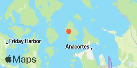
Ubicación y mapa
Latitud
48° 33' 54" N (48.565)
Longitud
122° 43' 19" W (-122.722)
Estado
Condado
Código postal cercano
98221
Cerca
Mareas
1.9 mi
Tide Point, Cypress Island
4.0 mi
Armitage Island, Thatcher Pass
4.3 mi
Peavine Pass
4.5 mi
Ship Harbor, Fidalgo Island
5.7 mi
Anacortes, Guemes Channel
7.4 mi
Burrows Bay (Allan Island)
7.5 mi
Upright Head, Lopez Island
8.8 mi
Rosario, East Sound, Orcas Island
9.2 mi
Telegraph Bay
9.5 mi
Shaw Island, Ferry Terminal, Harney Channel, San Juan Channel
10.5 mi
Village Point, Lummi Island
10.7 mi
Orcas, Orcas Island
10.9 mi
Deception Pass St. Park, Bowman Bay, Fidalgo I.
11.3 mi
Turner Bay, Similk Bay
11.4 mi
Aleck Bay, Lopez Island
11.6 mi
Richardson, Lopez Island, San Juan Channel
11.6 mi
Yokeko Point, Deception Pass
11.7 mi
Gooseberry Point, Hale Passage
12.1 mi
Swinomish Channel entrance, Padilla Bay
12.2 mi
Cornet Bay, Deception Pass
Corrientes
1.5 mi
Strawberry Island, west of
2.5 mi
Bellingham Channel South
2.8 mi
Bellingham Channel, off Cypress Head Light
3.4 mi
Towhead Island, 0.4 mile east of
3.5 mi
Bellingham Channel North Entrance
3.7 mi
Fauntleroy Point Light, east of
4.1 mi
Peapod Rocks Light, 1.2 nm south of
4.2 mi
Green Point, 0.8 mile northwest of
4.4 mi
Guemes Channel, West Entrance
4.6 mi
Thatcher Pass
4.7 mi
Peavine Pass, west entrance
4.7 mi
Belle Rock Light, east of
4.9 mi
Obstruction Pass, north of Obstruction Island
5.3 mi
Frost-Willow Island, between
5.5 mi
Burrows Pass
5.9 mi
Guemes Channel, East Entrance
6.2 mi
Sinclair Island, 1.0 nm NE of
6.5 mi
Allan Pass
7.2 mi
Huckleberry Island, 0.5 mile north of
7.3 mi
Burrows Bay, 0.5 mile east of Allan I
7.4 mi
Lopez Pass
7.5 mi
Rosario Strait
7.5 mi
Saddle Bag Island Passage
7.9 mi
Lawrence Point, Orcas Island, 1.3 nm NE of
8.9 mi
Barnes Island, 0.8 mile southwest of
9.2 mi
Upright Channel narrows
9.3 mi
Harney Channel, north of Point Hudson
10.5 mi
Point Colville, 1.4 nm east of
10.6 mi
Point Colville, 3.0 nm east of (Lawson Reef, 1 nm
10.9 mi
Raccoon Point, 0.6 mile NNE of
11.2 mi
Pear Point, east of
11.6 mi
Deception Pass (Narrows)
11.7 mi
Yokeko Point, Deception Pass
11.7 mi
Clark Island, 1.6 nm north of
11.9 mi
Hale Passage, east of Lummi Point
12.1 mi
Kings Point, Lopez Island, 1 mile NNW of
12.2 mi
Colville Island, 1 mile SSE of
12.4 mi
Wasp Passage narrows
Fuente de las predicciones de mareas:
NOAA
Referencia vertical:
MLLW — Mean Lower Low Water
Nota: Las predicciones de mareas son estimaciones y NO DEBEN USARSE PARA NAVEGAR.
Widgets gratuitos también están disponibles para añadir tablas de mareas o solunares a tu sitio.