Florida Passage Tables et graphiques hebdomadaires des marées
Graphique des marées des 7 prochains jours
Légende du graphique hebdomadaire des marées de Florida Passage :
Le graphique indique les horaires et hauteurs des pleines et basses mers à Florida Passage pour les sept prochains jours. La ligne rouge indique l’heure actuelle et la hauteur estimée.Le marnage à Florida Passage pour les sept prochains jours est d’environ 8.64 ft, avec une hauteur minimale de 0.22 ft et une maximale de 8.86 ft. Vous pouvez aussi consulter les marées et horaires de pêche de Florida Passage dans l’onglet Jour.
Table des marées des 7 prochains jours
▲ Bleu = Pleine mer
▼ Rouge = Basse mer
| Jour | Phase lunaire | 1st Marée | 2nd Marée | 3rd Marée | 4th Marée | ☀ Soleil |
Solunaires majeures

|
Solunaires mineures

|
|---|---|---|---|---|---|---|---|---|
| 8 jeu. |
 8%
8%
|
▼ 0.47 ft |
▲ 8.41 ft |
▼ 0.27 ft |
▲ 8.57 ft |
▲ 07:23 ▼ 19:01 | 10:38 → 12:38 |
04:48 → 05:48 17:20 → 18:20 |
| 9 ven. |
3%
|
▼ 0.3 ft |
▲ 8.7 ft |
▼ 0.22 ft |
▲ 8.51 ft |
▲ 07:24 ▼ 18:59 |
23:05 → 01:05 11:23 → 13:23 |
05:50 → 06:50 17:48 → 18:48 |
| 10 sam. |
 0%
0%
|
▼ 0.23 ft |
▲ 8.85 ft |
▼ 0.26 ft |
▲ 8.35 ft |
▲ 07:24 ▼ 18:58 |
23:49 → 01:49 12:07 → 14:07 |
06:50 → 07:50 18:17 → 19:17 |
| 11 dim. |
 1%
1%
|
▼ 0.28 ft |
▲ 8.86 ft |
▼ 0.4 ft |
▲ 8.11 ft |
▲ 07:25 ▼ 18:57 |
00:34 → 02:34 12:53 → 14:53 |
07:51 → 08:51 18:48 → 19:48 |
| 12 lun. |
2%
|
▼ 0.42 ft |
▲ 8.72 ft |
▼ 0.62 ft |
▲ 7.8 ft |
▲ 07:26 ▼ 18:56 |
01:20 → 03:20 13:40 → 15:40 |
08:52 → 09:52 19:23 → 20:23 |
| 13 mar. |
6%
|
▼ 0.64 ft |
▲ 8.48 ft |
▼ 0.89 ft |
▲ 7.47 ft |
▲ 07:27 ▼ 18:55 |
02:07 → 04:07 14:28 → 16:28 |
09:52 → 10:52 20:02 → 21:02 |
| 14 mer. |
11%
|
▼ 0.9 ft |
▲ 8.17 ft |
▼ 1.21 ft |
▲ 07:27 ▼ 18:53 |
02:56 → 04:56 15:19 → 17:19 |
10:51 → 11:51 20:45 → 21:45 |
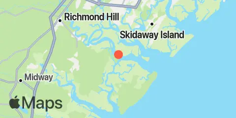
Localisation et carte
Latitude
31° 51' 12" N (31.8533)
Longitude
81° 8' 48" W (-81.1467)
État
Comté
Code postal le plus proche
31419
À proximité
Marées
2.5 mi
Cane Patch Creek entrance
2.8 mi
Florida Passage, Bear River
4.0 mi
Egg Islands
4.6 mi
Fort McAllister, Ogeechee River
4.6 mi
Bear River, (Range 'A' Light)
5.5 mi
Coffee Bluff, Forest River
5.6 mi
Kilkenny Club, Kilkenny Creek
5.6 mi
Little Wassaw Island, Green Island Sound
5.8 mi
Vernon View, Burnside River
6.1 mi
Bradley Point, Bradley River
9.0 mi
South Ossabaw Island, Bear River
9.2 mi
Belfast, Belfast River
9.8 mi
Sunbury, Sunbury Channel
10.2 mi
Romerly Marsh Creek
10.4 mi
Richmond Hill, Ogeechee River
10.6 mi
Isle of Hope, Skidaway River
11.0 mi
Priest Landing, Wilmington River
11.3 mi
Walburg Creek entrance
11.9 mi
Skidaway Institute, Skidaway River
12.0 mi
Highway bridge, Ogeechee River
12.2 mi
North Newport River (Daymark 119)
Courants
0.3 mi
Florida Passage, N of, Ogeechee River
1.8 mi
Florida Passage (south)
3.4 mi
610 Statute Mile Mark
3.7 mi
Little Ogeechee River Entrance
4.2 mi
Vernon R., 1.2 miles S of Possum Point
4.3 mi
Little Ogeechee River Entrance, north of
4.5 mi
Little Don Island, east of, Vernon River
4.7 mi
Raccoon Key & Egg Island Shoal, between
4.9 mi
North of Big Tom Creek Entrance
5.4 mi
Raccoon Key
5.8 mi
Montgomery, Vernon River
5.8 mi
Little Wassaw Island, SW of
6.1 mi
Burnside Island, SE of, Burnside River
6.5 mi
Bradley Point, NNE of
6.8 mi
South of Kilkenny Creek Entrance
7.1 mi
Pigeon Island, SSE of, Skidaway River
7.3 mi
Northwest of Newell Creek Entrance
7.6 mi
Long Island, south of, Skidaway River
8.1 mi
Wassaw Island, SSW of
8.4 mi
Skidaway Narrows
8.7 mi
Odingsell River Entrance
8.7 mi
Medway River at Marsh Island
8.8 mi
Long Island, NNE of, Skidaway River
9.6 mi
St. Catherines Sound Entrance
9.7 mi
Burntpot Island, west of, Skidaway River
9.9 mi
Medway River, northwest of Cedar Point
10.3 mi
Isle of Hope City, Skidaway River
10.4 mi
Isle of Hope City, SE of, Skidaway River
11.4 mi
Joe's Cut, Wilmington River
11.5 mi
N. Newport River, NE of Vandyke Creek
11.6 mi
Wilmington River ent. off Cabbage Island
12.1 mi
Dutch Island, SE of, Skidaway River
Source des prévisions de marées :
NOAA
Référence verticale :
MLLW — Mean Lower Low Water
Remarque : Les prévisions de marées sont des estimations et NE DOIVENT PAS SERVIR À LA NAVIGATION.
Widgets gratuits sont également disponibles pour ajouter des tables de marées ou solunaires à votre site.