Corkscrew Slough Tables et graphiques hebdomadaires des marées
Graphique des marées des 7 prochains jours
Légende du graphique hebdomadaire des marées de Corkscrew Slough :
Le graphique indique les horaires et hauteurs des pleines et basses mers à Corkscrew Slough pour les sept prochains jours. La ligne rouge indique l’heure actuelle et la hauteur estimée.Le marnage à Corkscrew Slough pour les sept prochains jours est d’environ 8.29 ft, avec une hauteur minimale de -0.01 ft et une maximale de 8.28 ft. Vous pouvez aussi consulter les marées et horaires de pêche de Corkscrew Slough dans l’onglet Jour.
Table des marées des 7 prochains jours
▲ Bleu = Pleine mer
▼ Rouge = Basse mer
| Jour | Phase lunaire | 1st Marée | 2nd Marée | 3rd Marée | 4th Marée | ☀ Soleil |
Solunaires majeures

|
Solunaires mineures

|
|---|---|---|---|---|---|---|---|---|
| 8 jeu. |
 8%
8%
|
▼ 0.45 ft |
▲ 7.98 ft |
▼ 1.01 ft |
▲ 7.62 ft |
▲ 07:11 ▼ 18:41 |
10:27 → 12:27 22:55 → 00:55 |
04:37 → 05:37 17:07 → 18:07 |
| 9 ven. |
3%
|
▼ 0.84 ft |
▲ 8.16 ft |
▼ 0.55 ft |
▲ 07:12 ▼ 18:40 | 11:12 → 13:12 |
05:43 → 06:43 17:32 → 18:32 |
|
| 10 sam. |
 0%
0%
|
▲ 7.46 ft |
▼ 1.32 ft |
▲ 8.26 ft |
▼ 0.22 ft |
▲ 07:13 ▼ 18:38 |
23:39 → 01:39 11:56 → 13:56 |
06:47 → 07:47 17:57 → 18:57 |
| 11 dim. |
 1%
1%
|
▲ 7.28 ft |
▼ 1.84 ft |
▲ 8.28 ft |
▼ 0.04 ft |
▲ 07:13 ▼ 18:37 |
00:24 → 02:24 12:42 → 14:42 |
07:52 → 08:52 18:25 → 19:25 |
| 12 lun. |
2%
|
▲ 7.09 ft |
▼ 2.36 ft |
▲ 8.23 ft |
▼ -0.01 ft |
▲ 07:14 ▼ 18:36 |
01:10 → 03:10 13:29 → 15:29 |
08:56 → 09:56 18:57 → 19:57 |
| 13 mar. |
6%
|
▲ 6.9 ft |
▼ 2.84 ft |
▲ 8.1 ft |
▼ 0.05 ft |
▲ 07:15 ▼ 18:34 |
01:58 → 03:58 14:18 → 16:18 |
09:59 → 10:59 19:33 → 20:33 |
| 14 mer. |
11%
|
▲ 6.71 ft |
▼ 3.24 ft |
▲ 7.92 ft |
▼ 0.21 ft |
▲ 07:16 ▼ 18:33 |
02:46 → 04:46 15:09 → 17:09 |
11:00 → 12:00 20:16 → 21:16 |
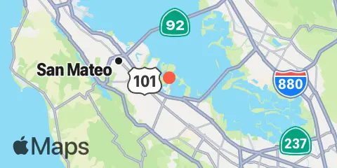
Localisation et carte
Latitude
37° 30' 30" N (37.5083)
Longitude
122° 12' 36" W (-122.21)
État
Comté
Code postal le plus proche
94063
À proximité
Marées
0.1 mi
Redwood City, Wharf 5, San Francisco Bay
0.8 mi
Smith Slough, San Francisco Bay
0.9 mi
Granite Rock, Redwood Creek, San Francisco Bay
1.0 mi
West Point Slough, San Francisco Bay
2.0 mi
Redwood Creek Marker 8, San Francisco Bay
2.6 mi
Bay Slough, east end, San Francisco Bay
3.5 mi
Bay Slough, west end, San Francisco Bay
4.0 mi
South Bay Wreck, San Francisco Bay
5.2 mi
Dumbarton Highway Bridge, San Francisco Bay
5.5 mi
San Mateo Bridge (west end), San Francisco Bay
5.9 mi
Coyote Hills Slough entrance, San Francisco Bay
6.7 mi
Palo Alto Yacht Harbor, San Francisco Bay
7.0 mi
Alameda Creek, San Francisco Bay
7.1 mi
San Mateo Bridge (east end), San Francisco Bay
7.1 mi
Newark Slough, San Francisco Bay
8.1 mi
Coyote Point Marina, San Francisco Bay
8.4 mi
Calaveras Point, west of, San Francisco Bay
9.3 mi
Mowry Slough, San Francisco Bay
10.7 mi
Coyote Creek, Alviso Slough, San Francisco Bay
11.0 mi
Roberts Landing, 1.3 miles west of, San Francisco Bay
12.2 mi
Upper Guadalupe Slough, San Francisco Bay
Courants
1.3 mi
Redwood Creek
3.1 mi
Redwood Point, 1.7nm East of
3.5 mi
Redwood Pt., Blair I., 1.15 nmi. NNE of
5.2 mi
Dumbarton Highway Bridge
5.2 mi
Dumbarton Hwy. Bridge, 0.28 nmi. SE of
5.9 mi
San Mateo Bridge
6.1 mi
Little Coyote Pt., 1.2 nmi. NE of
6.2 mi
Little Coyote Pt., 3.1 nmi. ENE of
7.2 mi
Dumbarton Point, 1.15 nmi. SE of
8.0 mi
Dumbarton Point, 2.25 miles SE of
8.1 mi
Little Coyote Pt., 3.4 nmi. NNE of
9.4 mi
Coyote Point, 2.3 nmi. NNE of
10.2 mi
Mulford Gardens Channel Approach
12.1 mi
Oakland Airport, southwest of
12.3 mi
Sierra Point, 4.4 miles east of
Source des prévisions de marées :
NOAA
Référence verticale :
MLLW — Mean Lower Low Water
Remarque : Les prévisions de marées sont des estimations et NE DOIVENT PAS SERVIR À LA NAVIGATION.
Widgets gratuits sont également disponibles pour ajouter des tables de marées ou solunaires à votre site.