Chelsea Tables et graphiques hebdomadaires des marées
Graphique des marées des 7 prochains jours
Légende du graphique hebdomadaire des marées de Chelsea :
Le graphique indique les horaires et hauteurs des pleines et basses mers à Chelsea pour les sept prochains jours. La ligne rouge indique l’heure actuelle et la hauteur estimée.Le marnage à Chelsea pour les sept prochains jours est d’environ 6.39 ft, avec une hauteur minimale de -0.08 ft et une maximale de 6.31 ft. Vous pouvez aussi consulter les marées et horaires de pêche de Chelsea dans l’onglet Jour.
Table des marées des 7 prochains jours
▲ Bleu = Pleine mer
▼ Rouge = Basse mer
| Jour | Phase lunaire | 1st Marée | 2nd Marée | 3rd Marée | 4th Marée | ☀ Soleil |
Solunaires majeures

|
Solunaires mineures

|
|---|---|---|---|---|---|---|---|---|
| 8 jeu. |
 8%
8%
|
▼ 0.02 ft |
▲ 5.9 ft |
▼ 0.22 ft |
▲ 5.85 ft |
▲ 07:01 ▼ 18:27 |
10:09 → 12:09 22:37 → 00:37 |
04:15 → 05:15 16:52 → 17:52 |
| 9 ven. |
3%
|
▼ -0.08 ft |
▲ 6.17 ft |
▼ 0.11 ft |
▲ 5.84 ft |
▲ 07:02 ▼ 18:26 | 10:54 → 12:54 |
05:23 → 06:23 17:14 → 18:14 |
| 10 sam. |
 0%
0%
|
▼ -0.07 ft |
▲ 6.31 ft |
▼ 0.07 ft |
▲ 5.72 ft |
▲ 07:03 ▼ 18:24 |
23:22 → 01:22 11:38 → 13:38 |
06:30 → 07:30 17:37 → 18:37 |
| 11 dim. |
 1%
1%
|
▼ 0.03 ft |
▲ 6.31 ft |
▼ 0.1 ft |
▲ 5.5 ft |
▲ 07:04 ▼ 18:23 |
00:07 → 02:07 12:24 → 14:24 |
07:37 → 08:37 18:02 → 19:02 |
| 12 lun. |
2%
|
▼ 0.22 ft |
▲ 6.18 ft |
▼ 0.22 ft |
▲ 5.22 ft |
▲ 07:05 ▼ 18:21 |
00:53 → 02:53 13:11 → 15:11 |
08:44 → 09:44 18:31 → 19:31 |
| 13 mar. |
6%
|
▼ 0.46 ft |
▲ 5.94 ft |
▼ 0.42 ft |
▲ 4.9 ft |
▲ 07:06 ▼ 18:20 |
01:40 → 03:40 14:00 → 16:00 |
09:49 → 10:49 19:06 → 20:06 |
| 14 mer. |
11%
|
▼ 0.74 ft |
▲ 5.66 ft |
▼ 0.68 ft |
▲ 4.6 ft |
▲ 07:07 ▼ 18:18 |
02:29 → 04:29 14:50 → 16:50 |
10:52 → 11:52 19:46 → 20:46 |
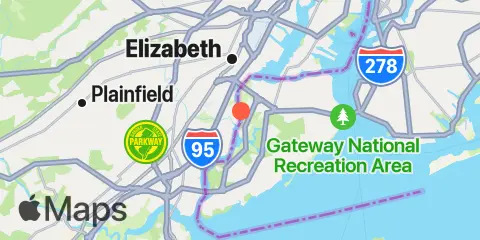
Localisation et carte
Latitude
40° 36' 0" N (40.6)
Longitude
74° 12' 0" W (-74.2)
État
Comté
Code postal le plus proche
10314
À proximité
Marées
1.1 mi
Carteret, Arthur Kill
1.7 mi
Rahway River, RR. Bridge, Arthur Kill
3.2 mi
Rossville, Arthur Kill
3.3 mi
Port Ivory, Howland Hook, Arthur Kill
3.9 mi
Bergen Point West Reach, Kill Van Kull
3.9 mi
Port Reading, Arthur Kill
5.0 mi
Great Kills Harbor
5.1 mi
Woodbridge Creek, 0.8 n.mi. above entrance, Arthur Kill
6.0 mi
Port Elizabeth
6.1 mi
Princes Bay
7.1 mi
Constable Hook, Kill Van Kull
7.1 mi
Port Newark Terminal
7.3 mi
St. George, Staten Island
7.4 mi
USCG Station, The Narrows
8.6 mi
South Amboy, Raritan River
8.6 mi
Keasbey, Raritan River
8.7 mi
Fort Hamilton, The Narrows
10.1 mi
Point No Point, Passaic River
10.2 mi
Kearny Point, Hackensack River
10.6 mi
Norton Point, Gravesend Bay
10.8 mi
Gowanus Bay
10.9 mi
Cheesequake Creek, Garden State Parkway
10.9 mi
Waackaack Creek
11.1 mi
Keyport
11.6 mi
Matawan Creek, Route 35 bridge
11.6 mi
Coney Island
11.8 mi
Sayreville, Raritan River
11.8 mi
Amtrak RR. swing bridge, Hackensack River
12.0 mi
The Battery, New York Harbor
Courants
0.8 mi
Tremley Point
2.0 mi
Gulfport, Arthur Kill
3.2 mi
Tufts Point-Smoking Point
3.4 mi
Elizabethport
3.9 mi
Bergen Point
4.0 mi
Newark Bay Entrance LB 18
4.1 mi
Bayonne Bridge
4.4 mi
Kill Van Kull LB 14, east of Bayonne Bridge
4.8 mi
Bergen Point, East Reach
5.1 mi
South Reach, Newark Bay
6.3 mi
Middle Reach, Newark Bay
6.7 mi
Tottenville, Arthur Kill River
6.7 mi
Seguine Point
6.8 mi
New Dorp Beach, 1.2 miles south of
7.1 mi
Hoffman Island, 0.2 mile west of
7.8 mi
Ward Point, ESE
7.9 mi
Ward Point Bend
7.9 mi
Bay Ridge, west of
7.9 mi
Raritan River Entrance, Victory Bridge
8.1 mi
Constable Hook Approach
8.2 mi
Red Bank, 1.4 miles south of
8.5 mi
The Narrows
8.7 mi
Robbins Reef Light, 0.6 nm E of
8.7 mi
Old Orchard Shoal Lt., 1.2 mi. ENE of
8.8 mi
Raritan Bay Reach Channel
9.8 mi
Gowanus Flats LBB 32
9.9 mi
Norton Point, WSW of
10.2 mi
Lincoln Highway Bridge, Passaic River
10.3 mi
Coney Island Channel, west end
10.5 mi
Gowanus Bay Entrance
10.5 mi
Red Hook Channel
10.6 mi
Lincoln Highway Bridge, Hackensack River
10.8 mi
Coney Island Lt., 1.5 miles SSE of
10.9 mi
Statue of Liberty, east of
11.6 mi
Dimond Reef
11.7 mi
Chapel Hill Channel, South End
11.8 mi
Hudson River Entrance
Source des prévisions de marées :
NOAA
Référence verticale :
MLLW — Mean Lower Low Water
Remarque : Les prévisions de marées sont des estimations et NE DOIVENT PAS SERVIR À LA NAVIGATION.
Widgets gratuits sont également disponibles pour ajouter des tables de marées ou solunaires à votre site.