Pablo Creek Entrance Tables et graphiques hebdomadaires des marées
Graphique des marées des 7 prochains jours
Légende du graphique hebdomadaire des marées de Pablo Creek Entrance :
Le graphique indique les horaires et hauteurs des pleines et basses mers à Pablo Creek Entrance pour les sept prochains jours. La ligne rouge indique l’heure actuelle et la hauteur estimée.Le marnage à Pablo Creek Entrance pour les sept prochains jours est d’environ 4.7 ft, avec une hauteur minimale de 0.31 ft et une maximale de 5.01 ft. Vous pouvez aussi consulter les marées et horaires de pêche de Pablo Creek Entrance dans l’onglet Jour.
Table des marées des 7 prochains jours
▲ Bleu = Pleine mer
▼ Rouge = Basse mer
| Jour | Phase lunaire | 1st Marée | 2nd Marée | 3rd Marée | 4th Marée | ☀ Soleil |
Solunaires majeures

|
Solunaires mineures

|
|---|---|---|---|---|---|---|---|---|
| 8 jeu. |
 8%
8%
|
▼ 0.45 ft |
▲ 4.78 ft |
▼ 0.39 ft |
▲ 4.82 ft |
▲ 07:24 ▼ 19:03 | 10:39 → 12:39 |
04:50 → 05:50 17:21 → 18:21 |
| 9 ven. |
3%
|
▼ 0.35 ft |
▲ 4.94 ft |
▼ 0.36 ft |
▲ 4.75 ft |
▲ 07:24 ▼ 19:01 |
23:05 → 01:05 11:24 → 13:24 |
05:50 → 06:50 17:50 → 18:50 |
| 10 sam. |
 0%
0%
|
▼ 0.31 ft |
▲ 5.01 ft |
▼ 0.38 ft |
▲ 4.64 ft |
▲ 07:25 ▼ 19:00 |
23:50 → 01:50 12:08 → 14:08 |
06:50 → 07:50 18:20 → 19:20 |
| 11 dim. |
 1%
1%
|
▼ 0.33 ft |
▲ 5.01 ft |
▼ 0.46 ft |
▲ 4.48 ft |
▲ 07:25 ▼ 18:59 |
00:35 → 02:35 12:54 → 14:54 |
07:50 → 08:50 18:52 → 19:52 |
| 12 lun. |
2%
|
▼ 0.41 ft |
▲ 4.93 ft |
▼ 0.58 ft |
▲ 4.3 ft |
▲ 07:26 ▼ 18:58 |
01:21 → 03:21 13:41 → 15:41 |
08:50 → 09:50 19:28 → 20:28 |
| 13 mar. |
6%
|
▼ 0.55 ft |
▲ 4.79 ft |
▼ 0.75 ft |
▲ 4.12 ft |
▲ 07:27 ▼ 18:57 |
02:09 → 04:09 14:30 → 16:30 |
09:50 → 10:50 20:07 → 21:07 |
| 14 mer. |
11%
|
▼ 0.71 ft |
▲ 4.62 ft |
▼ 0.92 ft |
▲ 07:27 ▼ 18:56 |
02:57 → 04:57 15:20 → 17:20 |
10:48 → 11:48 20:51 → 21:51 |
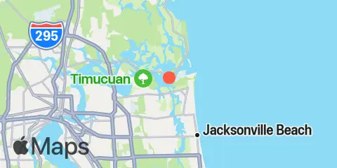
Localisation et carte
Latitude
30° 22' 36" N (30.3767)
Longitude
81° 26' 54" W (-81.4483)
État
Comté
Code postal le plus proche
32226
À proximité
Marées
1.5 mi
Mayport (Ferry Depot)
1.9 mi
Bar Pilot Dock, St. Johns River
2.6 mi
Water Treatment Dock, Mayport Naval Station, St Johns River
2.8 mi
Sisters Creek
3.5 mi
Degaussing structure, Mayport Naval Station
3.6 mi
Fulton
3.7 mi
Pablo Creek, ICWW bridge
4.2 mi
Clapboard Creek, Pelotes Island
4.3 mi
Atlantic Beach
4.4 mi
Fort George Island, Fort George River
4.5 mi
Little Talbot Island, Ocean
6.2 mi
Simpson Creek, A1A highway bridge
6.3 mi
Blount Island Bridge
6.6 mi
Dame Point, St. Johns River
7.4 mi
Jacksonville Beach
8.6 mi
Oak Landing, ICWW
8.9 mi
Sawpit Creek, 1 mi. above entrance
9.1 mi
Tiger Point, Pumpkin Hill Creek, Nassau River
9.5 mi
Sawpit Creek entrance, bridge
9.8 mi
Nassau River entrance
10.3 mi
Edwards Creek, Nassau River
10.3 mi
Jacksonville, Long Branch
10.7 mi
Little Pottsburg Creek
10.8 mi
Jacksonville, Navy Fuel Depot
11.2 mi
Phoenix Park
12.3 mi
Cedar Heights, Broward River
Courants
0.6 mi
ICW Intersection
0.6 mi
Mile Point LB 20
1.2 mi
Sisters Creek entrance (bridge)
1.5 mi
Mayport
3.0 mi
St. Johns Bluff
3.4 mi
St. Johns Bar Cut, 0.7 n.mi. east of jetties
3.5 mi
Mayport Basin Entrance
3.7 mi
Pablo Creek bascule bridge
3.8 mi
Blount Island, East of
4.1 mi
St. Johns River Ent. (between jetties)
4.7 mi
Bar Cut, 0.6 n.mi. ENE of St. John's Point
5.5 mi
Ft. George River
6.3 mi
Dames Point, 0.23 n.mi. ESE of
6.6 mi
Dames Point Bridge
9.5 mi
Drummond Point, channel south of
10.1 mi
Midsound, 1 mi. N of Sawpit Creek entrance
10.2 mi
Terminal Channel (north end)
10.7 mi
Reddie Point
10.7 mi
Trout River Cut
10.7 mi
Chaseville Turn
11.0 mi
Nassau River, SW of Mesa Marsh
11.1 mi
South Amelia River, off Walker Creek
11.4 mi
Commodore Point, terminal channel
Source des prévisions de marées :
NOAA
Référence verticale :
MLLW — Mean Lower Low Water
Remarque : Les prévisions de marées sont des estimations et NE DOIVENT PAS SERVIR À LA NAVIGATION.
Widgets gratuits sont également disponibles pour ajouter des tables de marées ou solunaires à votre site.