Glen Cove Yacht Club Wöchentliche Gezeitentabellen und -diagramme
Gezeitendiagramm für die nächsten 7 Tage
Legende zum wöchentlichen Gezeitendiagramm für Glen Cove Yacht Club:
Das Gezeitendiagramm oben zeigt Zeiten und Höhen von Hoch- und Niedrigwasser für Glen Cove Yacht Club in den nächsten sieben Tagen. Die rote Linie markiert die aktuelle Zeit und die geschätzte Wasserhöhe.Der Tidenhub in Glen Cove Yacht Club in den nächsten sieben Tagen beträgt ungefähr 9.36 ft, bei einem niedrigsten Wasserstand von -0.67 ft und einem höchsten Wasserstand von 8.69 ft. Sie können auch alle täglichen Details zu Gezeiten und Angelzeiten auf der Registerkarte „Tag“ für Glen Cove Yacht Club ansehen.
Gezeitentabelle für die nächsten 7 Tage
▲ Blau = Hochwasser
▼ Rot = Niedrigwasser
| Tag | Mondphase | 1st Gezeit | 2nd Gezeit | 3rd Gezeit | 4th Gezeit | ☀ Sonne |
Große Solunarperioden

|
Kleine Solunarperioden

|
|---|---|---|---|---|---|---|---|---|
| 9 Fr |
 3%
3%
|
▼ -0.29 ft |
▲ 8.68 ft |
▼ -0.67 ft |
▲ 8.18 ft |
▲ 07:00 ▼ 18:23 | 10:52 → 12:52 |
05:21 → 06:21 17:12 → 18:12 |
| 10 Sa |
 0%
0%
|
▼ -0.2 ft |
▲ 8.69 ft |
▼ -0.65 ft |
▲ 07:01 ▼ 18:22 |
23:20 → 01:20 11:36 → 13:36 |
06:28 → 07:28 17:35 → 18:35 |
|
| 11 So |
 1%
1%
|
▲ 8.02 ft |
▼ 0 ft |
▲ 8.57 ft |
▼ -0.5 ft |
▲ 07:02 ▼ 18:20 |
00:05 → 02:05 12:22 → 14:22 |
07:35 → 08:35 18:00 → 19:00 |
| 12 Mo |
2%
|
▲ 7.79 ft |
▼ 0.27 ft |
▲ 8.37 ft |
▼ -0.24 ft |
▲ 07:03 ▼ 18:19 |
00:51 → 02:51 13:09 → 15:09 |
08:42 → 09:42 18:28 → 19:28 |
| 13 Di |
6%
|
▲ 7.52 ft |
▼ 0.56 ft |
▲ 8.13 ft |
▼ 0.08 ft |
▲ 07:04 ▼ 18:17 |
01:38 → 03:38 13:57 → 15:57 |
09:48 → 10:48 19:03 → 20:03 |
| 14 Mi |
11%
|
▲ 7.24 ft |
▼ 0.85 ft |
▲ 7.87 ft |
▼ 0.41 ft |
▲ 07:05 ▼ 18:16 |
02:27 → 04:27 14:48 → 16:48 |
10:51 → 11:51 19:42 → 20:42 |
| 15 Do |
18%
|
▲ 6.96 ft |
▼ 1.14 ft |
▲ 7.58 ft |
▼ 0.75 ft |
▲ 07:06 ▼ 18:14 |
03:16 → 05:16 15:39 → 17:39 |
11:49 → 12:49 20:30 → 21:30 |
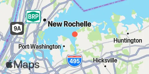
Ort und Karte
Breitengrad
40° 51' 48" N (40.8633)
Längengrad
73° 39' 18" W (-73.655)
Bundesstaat
County
Nächstgelegene US-Postleitzahl
11542
In der Nähe
Gezeiten
2.0 mi
Harry Tappen Marina, Hempstead Harbor, Long Island
3.3 mi
Port Washington, Manhasset Bay, Long Island
6.1 mi
Bayville Bridge, Oyster Bay
6.8 mi
Kings Point, Long Island Sound
6.9 mi
Rye Beach (Amusement Park)
6.9 mi
City Island
6.9 mi
New Rochelle
7.2 mi
Oyster Bay Harbor, Oyster Bay
8.2 mi
Willets Point, Little Bay, East River
8.4 mi
Throgs Neck
9.4 mi
Whitestone, East River
9.7 mi
Cold Spring Harbor, Oyster Bay
11.0 mi
Cos Cob Harbor
11.9 mi
College Pt, Ft. of 110th Street, Long Island
12.1 mi
Huntington Harbor Lighthouse, Huntington Bay, Long Island
12.2 mi
Hunts Point, East River
Strömungen
2.5 mi
Hempstead Harbor, off Glenwood Landing
3.5 mi
Matinecock Point, 0.7 mile NNW of
4.2 mi
Execution Rocks
4.2 mi
Matinecock Point, 1.7 miles northwest of
4.6 mi
Manhasset Bay entrance
4.7 mi
Delancey Point, 1 mile southeast of
4.9 mi
Huckleberry Island, 0.6 mile SE of
5.1 mi
Parsonage Point, 1.3 n.mi. ESE of
5.3 mi
Peningo Neck, 0.6 mi. off Parsonage Pt
5.7 mi
Huckleberry Island, 0.2 mile NW of
5.8 mi
Hart Island, southeast of
6.0 mi
Hart Island, 0.3 n.mi. SSE of
6.3 mi
Oak Neck Point, 0.6 mile north of
6.5 mi
Harbor, west of Soper Point
7.2 mi
City Island Bridge
7.6 mi
Eastchester Bay, near Big Tom
7.7 mi
Harbor ent., south of Plum Point
7.7 mi
Throgs Neck, 0.3 n.mi. NE of
8.3 mi
Greenwich Point, 2.5 miles south of
8.3 mi
Throgs Neck, 0.2 mile S of (Willets Point)
8.4 mi
Throgs Neck Bridge
8.4 mi
Throgs Neck, 0.4 mile south of
8.5 mi
Hutchinson R., Pelham Highway Bridge
8.7 mi
Cryders Point, 0.4 mile NNW of
9.0 mi
Rocky Point, 1 mile east of
9.5 mi
Greenwich Point, 1.1 miles south of
9.6 mi
Captain Hbr. Ent., 0.6 mile southwest of
9.9 mi
Bronx-Whitestone Bridge, East of
11.0 mi
Lloyd Point, 1.3 miles NNW of
11.0 mi
Cos Cob Harbor, off Goose Island
11.3 mi
College Point Reef, 0.25 n.mi. NW of
11.9 mi
Shippan Point, 1.3 miles SSE of
12.0 mi
The Cows, 2 miles SE of
12.2 mi
Stamford Harbor entrance
Quelle der Gezeitenvorhersagen:
NOAA
Höhenbezug:
MLLW — Mean Lower Low Water
Hinweis: Gezeitenvorhersagen sind Schätzungen und NICHT ZUR NAVIGATION GEEIGNET.
Kostenlose Widgets stehen ebenfalls zur Verfügung, um Gezeiten- oder Solunartabellen auf Ihrer eigenen Website einzubinden.