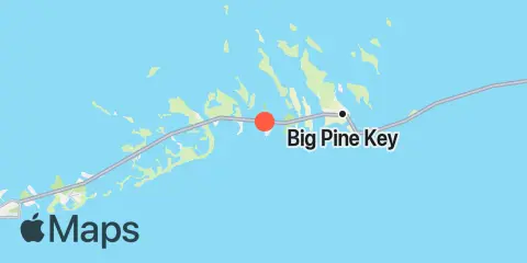
Summerland Key, southwest side, Kemp Channel 钓鱼时间
查看Summerland Key适合钓鱼的潮汐信息、主要和次要日月活动时段,以及七天钓鱼预测。
主要月相活动时段
03:57
05:57
低潮 · 08:19 · 0.06 ft
16:23
18:23
日落 ·
低潮 · 19:37 · 0.38 ft
基于月相活动时段。请同时考虑天气和水域状况。
潮汐与钓鱼时段
完整潮汐详情 →阴影区域表示主要钓鱼时段。鱼形标记表示所有主要和次要时段。
钓鱼时间
主要钓鱼时间
03:57 05:57
16:23 18:23
次要钓鱼时间
11:11 12:11
22:41 23:41
关于日月活动理论 →潮汐时间与潮高
| 潮汐 | 时间 | 高度 |
|---|---|---|
| 高潮 | 1.76′ | |
| 低潮 | 0.06′ | |
| 高潮 | 1.03′ | |
| 低潮 | 0.38′ |
天气与海况
2026年11月29日星期日
所选时段暂无预报。
大气压
此日期目前暂无气压预报。
太阳与月亮
月相
 亏凸月
照明比例 67%
太阳与月亮
- 日出
- 日落
- 月落
- 月出
7天钓鱼计划
每日评分、所有主要和次要月相活动时段,以及潮汐时间和潮高。
地点与地图
附近
潮汐
0.7 mi
Summerland Key, Niles Channel South
0.9 mi
Summerland Key, Niles Channel Bridge
1.6 mi
Kemp Channel Viaduct, Florida Keys
1.6 mi
Ramrod Key, Niles Channel Bridge
2.5 mi
Gopher Key, Cudjoe Bay
2.7 mi
Ramrod Key, Newfound Harbor
2.9 mi
Cudjoe Key, Cudjoe Bay
2.9 mi
Middle Torch Key, Torch Ramrod Channel
3.3 mi
Munson Island, Newfound Harbor Channel
3.3 mi
Key Lois, southeast end
3.4 mi
Little Torch Key, Torch Channel
3.9 mi
Big Torch Key, Niles Channel
3.9 mi
Little Torch Key, Pine Channel Bridge, South Side
4.3 mi
Sugarloaf Key, East Side, Tarpon Creek
4.3 mi
Sugarloaf Key, Pirates Cove
4.4 mi
Cudjoe Key, Pirates Cove
4.5 mi
Big Pine Key, Newfound Harbor Channel
4.6 mi
Tarpon Creek, Upper Sugarloaf Sound
4.9 mi
Big Pine Key, West Side, Pine Channel
4.9 mi
Big Pine Key, Pine Channel Bridge, South Side
4.9 mi
Knockemdown Key, North End
5.0 mi
Cudjoe Key, North End, Kemp Channel
5.1 mi
Big Pine Key, Pine Channel Bridge, North Side
5.6 mi
Sugarloaf Key, Northeast Side, Bow Channel
5.8 mi
Howe Key, South End, Harbor Channel
5.9 mi
Park Channel Bridge, Upper Sugarloaf Sound
6.0 mi
Big Torch Key, Harbor Channel
6.1 mi
Big Pine Key, Coupon Bight
6.3 mi
Big Pine Key, Doctors Arm, Bogie Channel
6.6 mi
Big Pine Key, Northeast Shore
6.7 mi
Water Keys, South End, Harbor Channel
6.7 mi
North Harris Channel, Upper Sugarloaf Sound
6.7 mi
Raccoon Key, East Side
7.0 mi
Big Pine Key, Bogie Channel Bridge
7.3 mi
Big Pine Key, North End
7.3 mi
Big Pine Key, Spanish Harbor
7.4 mi
Sugarloaf Key, North End, Bow Channel
7.6 mi
Howe Key, northwest end
7.6 mi
Porpoise Key, Big Spanish Channel
7.8 mi
Perky, Upper Sugarloaf Sound
7.9 mi
Mayo Key, Big Spanish Channel
8.3 mi
Annette Key, North End, Big Spanish Channel
8.6 mi
Pumpkin Key, Bow Channel
8.7 mi
No Name Key, East Side, Bahia Honda Channel
9.1 mi
Water Key, west end, Big Spanish Channel
9.2 mi
Crawl Key, Big Spanish Channel
9.8 mi
Big Spanish Key
9.8 mi
Little Spanish Key, Spanish Banks
10.0 mi
Content Keys, Content Passage
10.0 mi
Saddlebunch Keys, Channel No. 3
10.0 mi
Little Pine Key, South End
10.1 mi
Johnston Key, southwest end, Turkey Basin
10.2 mi
Little Pine Key, North End
10.2 mi
Snipe Keys, Southeast End, Inner Narrows
10.4 mi
Bahia Honda Key, Bahia Honda Channel
10.4 mi
Sawyer Key, Inside, Cudjoe Channel
11.0 mi
Saddlebunch Keys, Channel No. 4
11.2 mi
Johnson Keys, North End
11.3 mi
Johnson Keys, South End
11.4 mi
Saddlebunch Keys, Channel No. 5
11.5 mi
Saddlebunch Keys, Similar Sound
11.6 mi
Snipe Keys, Middle Narrows
12.3 mi
Ohio Key-Bahia Honda Key Channel, west side
关于这些潮汐预报
潮高是预测值,并非实测值。风、气压、风暴和河流流量可能导致实际水位与预测不同。不可用于航海导航。
潮汐预测来源:
Tide predictions: NOAA Center for Operational Oceanographic Products and Services (CO-OPS). 官方来源
垂直基准面:
MLLW — Mean Lower Low Water